Barry crawls ashore in Louisiana, weakens to tropical storm
NEW ORLEANS – “Barry” rolled into the Louisiana coast Saturday, flooding highways, forcing people to scramble to rooftops and dumping heavy rain that could test the levees and pumps that were bolstered after Hurricane Katrina devastated New Orleans in 2005.

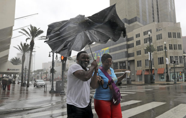
Karon Hill, left, and Celeste Cruz battle the wind and rain from Hurricane Barry as it nears landfall Saturday, July 13, 2019, in New Orleans. (AP Photo/David J. Phillip)
After briefly becoming a Category 1 hurricane, the system quickly weakened to a tropical storm as it made landfall near Intracoastal City, Louisiana, about 160 miles (257km) west of New Orleans, with its winds falling to 70 mph (112km), the National Hurricane Center said.
By late afternoon, New Orleans had been spared the storm’s worst effects, receiving only sporadic light showers and gusty winds. But officials warned that Barry could still cause disastrous flooding across a wide stretch of the Gulf Coast and drop up to 20 inches (50 cm) of rain through Sunday across a part of Louisiana that includes New Orleans and Baton Rouge.
“This is just the beginning,” Louisiana Gov. John Bel Edwards said. “It’s going to be a long several days for our state.”
The Coast Guard rescued more than a dozen people from the remote Isle de Jean Charles, south of New Orleans, where water rose so high that some residents clung to rooftops.
None of the main levees on the Mississippi River failed or were breached, Edwards said. But video showed water overtopping a levee in Plaquemines Parish south of New Orleans, where fingers of land extend deep into the Gulf of Mexico.
Officials in the rural Louisiana coastal parish of Terrebonne ordered an evacuation of some areas due to water overtopping another levee. It was unclear how many people would be affected. Evacuees with nowhere to go were directed to a shelter in Houma.
Nearly all businesses in Morgan City, about 85 miles west of New Orleans, were shuttered with the exception of Meche’s Donuts Shop. Owner Todd Hoffpauir did a brisk business despite the pounding winds and pulsating rain.
While making doughnuts, Hoffpauir said he heard an explosion and a ripping sound and later saw that the wind had peeled off layers of the roof at an adjacent apartment complex.
In some places, residents continued to build defenses. At the edge of the town of Jean Lafitte just outside New Orleans, volunteers helped several town employees sandbag a 600-foot stretch of the two-lane state highway. The street was already lined with one-ton sandbags, and 30-pound bags were being used to strengthen them.
“I’m here for my family, trying to save their stuff,” volunteer Vinnie Tortorich said. “My cousin’s house is already under.”
In Lafayette, Willie Allen and his 11-year-old grandson, Gavin Coleman, shoveled sand into 20 green bags, joining a group of more than 20 other people doing the same thing during a break in the rain. Wearing a mud-streaked T-shirt and shorts, Allen loaded the bags onto the back of his pickup.
“Everybody is preparing,” he said. “Our biggest concern is the flood.”
Many businesses were also shut down or closed early in Baton Rouge, and winds were strong enough to rock large pickup trucks. Whitecaps were visible on the Mississippi.
Oil and gas operators evacuated hundreds of platforms and rigs in the Gulf of Mexico. Nearly 70% of Gulf oil production and 56% of gas production were turned off Saturday, according to the U.S. Bureau of Safety and Environmental Enforcement, which compiles the numbers from industry reports.
The mood was sanguine in New Orleans, where locals and tourists wandered through mostly empty streets under a light rain or stayed indoors.
“I think whatever is going to happen, is going to happen,” said Wayne Wilkinson, a New Orleans resident. “So I’m not really paying too much attention to it as I probably should be.”
More than 70,000 customers were without power Saturday morning, including nearly 67,000 in Louisiana and more than 3,000 in Mississippi, according to poweroutage.us.
During a storm update through Facebook Live, National Hurricane Center Director Ken Graham pointed to a computer screen showing a huge, swirling mess of airborne water. “That is just an amazing amount of moisture,” he said. “That is off the chart.”
Barry was moving so slowly that heavy rain was expected to continue all weekend. Forecasts showed the storm on a path toward Chicago that would swell the Mississippi River basin with water that must eventually flow south again.
For a few hours, the storm had maximum sustained winds of 75 mph (120 kph), just above the 74 mph (120 kph) threshold to be a hurricane. Barry was expected to continue weakening and become a tropical depression on Sunday.
Downpours also lashed coastal Alabama and Mississippi. Parts of Dauphin Island, a barrier island in Alabama, were flooded both by rain and surging water from the Gulf, said Mayor Jeff Collier, who was driving around in a Humvee to survey damage. He said the island still had power Saturday afternoon and wind damage was minimal.
Flooding closed some roads in low-lying areas of Mobile County in Alabama and heavy rains contributed to a number of accidents, said John Kilcullen, director of plans and operations for Mobile County Emergency Management Agency. The National Weather Service issued a flash flood warning for much of the two coastal Alabama counties.
“The rain is our primary concern,” Kilcullen said.
Double red flags at Alabama beaches in Baldwin County warned tourists that waters were closed for swimming.
Governors declared emergencies in Louisiana and Mississippi, and authorities closed floodgates and raised water barriers around New Orleans. It was the first time since Katrina that all floodgates in the New Orleans area had been sealed. /gsg