Sendong heads for Palawan after pounding Visayas, Mindanao
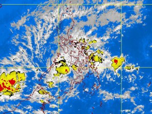
MANILA, Philippines — After leaving a trail of destruction in Mindanao and the Visayas, Tropical Storm Sendong (international codename: Washi) on Saturday swirled toward Palawan, threatening to pummel it with heavy rains and even stronger winds.
Sendong was forecast to make another landfall in Palawan around 8 p.m. Saturday before exiting the Philippine area of responsibility on Sunday, the Philippine Atmospheric, Geophysical and Astronomical Services Administration said.
“They should expect stormy weather there,’’ forecaster Jori Lois said in an interview.
At 10 a.m. Saturday, Signal No. 2 was hoisted over Palawan, southern Negros island and Zamboanga del Norte; while Signal No. 1 was up over Cuyo Island, Southern Cebu, Siquijor and Northern Negros, Zamboanga del Sur and Misamis Occidental.
By Sunday morning, Palawan would experience light to moderate rain while provinces earlier hit by the storm would have “improved weather,’’ Lois said.
Article continues after this advertisementSendong intensified slightly over the Sulu Sea on Saturday, packing maximum winds of 75 kilometers per hour that were gusting up to 90 kph, as it approached Palawan.
Article continues after this advertisementMoving west northwest at 30 kph, the storm was forecast to cross Palawan Saturday night and to be out of the Philippine area of responsibility by Sunday afternoon.
According to forecasters, a cyclone crosses Mindanao only once every 12 years.
While the storm was too far to affect the rest of the country, the convergence of the northeast monsoon and the easterlies, or winds from the east, was expected to bring rain over Metro Manila and other parts of Luzon Sunday.
