Pagasa raises alarm as ‘Lawin’ grows into a supertyphoon

The state weather bureau sounded the alarm after seeing incoming Typhoon “Lawin” (international name: Haima) further intensify while at sea.
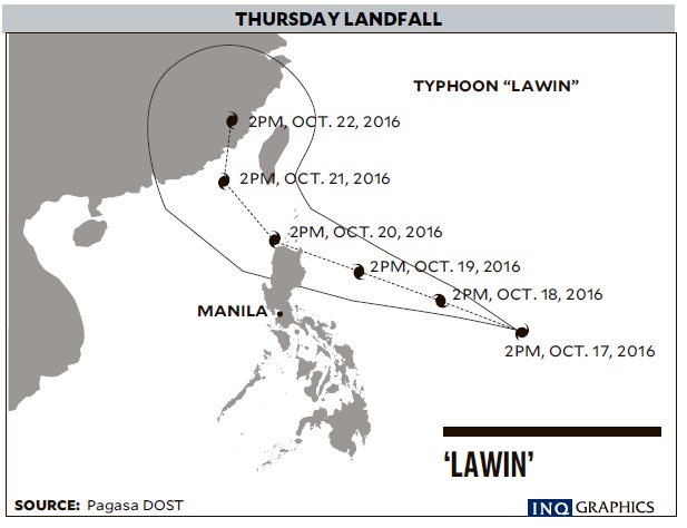
If Lawin maintains its west northwest course, it is projected to make landfall over Cagayan province early Thursday, according to the Philippine Atmospheric, Geophysical and Astronomical Services Administration (Pagasa).
“It will possibly be a supertyphoon. It’s also getting bigger,” said weather forecaster Jori Luiz.
600-km diameter
Luiz said initial analysis showed the howler would cross northern Luzon and affect Central Luzon as well if it ballooned into a 600-kilometer diameter, before exiting land via Ilocos Norte.
Stormy weather will start to be felt over eastern Luzon beginning on Wednesday.
Article continues after this advertisementAs of Monday afternoon as it crossed the Philippine area of responsibility, Lawin was packing 150 kph winds near the center and gusts up to 185 kph, which was equivalent to the peak of Typhoon “Karen” (international name: Sarika) when it slammed into Central and northern Luzon over the weekend.
Article continues after this advertisementPagasa categorizes a cyclone as a supertyphoon when it reaches sustained winds of at least 220 kph.
“As of now it’s not yet 100 percent sure that Lawin will be a supertyphoon, although it is intensifying,” said Pagasa weather division chief Esperanza Cayanan.
If ever Lawin becomes one, it will be the country’s first supertyphoon since “Yolanda” (international name: Haiyan).
Yolanda was the world’s strongest recorded cyclone, whipping maximum winds of up to 315 kph and gusts up to 380 kph before it slammed into the Visayas on Nov. 6, 2013, killing at least 6,000 persons and causing unprecedented devastation.
Batanes and the nearby Babuyan islands and the country’s northernmost provinces are still recovering from last month’s back-to-back typhoons.
Authorities reported a fourth fatality from Karen. Heidi Maulino, 60, was killed on Sunday in Llanera, Nueva Ecija, when her house was crushed by a tree felled by the typhoon.
The National Disaster Risk Reduction and Management Council reported on Monday that Karen’s damage to agriculture had breached the P2-billion mark, affecting 17,157 families, or 80,458 persons, in 260 barangays in the provinces of Aurora, Bulacan, Nueva Ecija and Zambales.
The council said Aurora reported heavy damage to crops valued at P39,049,932.40; Bulacan, P11,366,395.60; Nueva Ecija, P1,038,678,907.70; Tarlac, P1,047,968,255.88 and Pampanga, P4,338,644.
Damaged houses totaled 3,864, mostly in Aurora. The province reported 491 totally damaged and 3,373 partially damaged houses.
Tarlac also reported four partially damaged houses, mainly in the town of Gerona.
Flooding was reported in 11 villages in Bulacan, 12 in Pampanga, 16 in Nueva Ecija, six in Rizal, two in San Jose City, and one each in Palayan City and Cabanatuan City.
Roads and bridges were still not passable in Aurora, Bulacan and in certain parts of Nueva Ecija.
The council has not given its count of persons killed, saying the names and the cause of death have to be verified yet.
Mountaineers
The eight members of Rabas Oragon Mountaineers and four tour guides who were first reported missing on Mount Mingan, Dingalan, Aurora, on Oct. 15 were reported safe the next day and were with Roger Villa, a local resident in Dabildabilan.
Also, the 100 stranded mountaineers on Mount Tarak in Mariveles, Bataan, have been rescued.
At least 64 cities and towns suspended classes in Aurora, Bataan, Nueva Ecija, Pampanga and Tarlac. —WITH REPORTS FROM MAR S. ARGUELLES, ARMAND GALANG, ANSELMO ROQUE, VILLAMOR VISAYA JR., TONETTE OREJAS, AND GABRIEL CARDINOZA