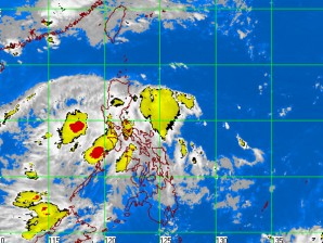
‘Ramon’ slows down further, moves towards West Philippine Sea
MANILA, Philippines—Tropical Depression “Ramon” has further slowed down as it moves towards the West Philippine Sea, the state-run weather bureau said early Thursday.
In its 5 a.m. bulletin, the Philippine Atmospheric Geophysical and Astronomical Services Administration said that as of 4 a.m., Ramon was estimated at 80 kilometers west northwest of San Jose, Occidental Mindoro.
Central and southern Luzon and western Visayas will experience cloudy skies with scattered to widespread rainshowers and thuderstorms which may trigger flashfloods and landslides, Pagasa said.
The rest of the Philippines will be mostly cloudy with scattered rainshowers and thunderstorms, Pagasa added.
Ramon, which has maximum sustained winds of 55 kilometers per hour near the center, is forecast to move in a northwest direction at 11 kph, Pagasa said.
Article continues after this advertisementSignal No. 1 remains hoisted over Metro Manila, Marinduque, Mindoro Provinces including Lubang Island, Romblon, southern Quezon, northern Palawan including Calamian Group of Islands, Cavite, Laguna, Batangas, Bataan and southern Zambales.
Article continues after this advertisementThe weather bureau said that public storm warning signals elsewhere were now lowered.
By Friday morning, Ramon will be at 240 km west southwest of Iba, Zambales and at 580 km west northwest of Iba, Zambales by Saturday morning, Pagasa said.
