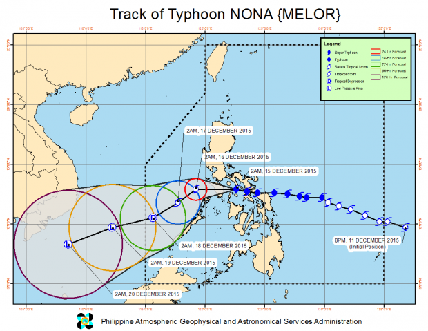
‘Nona’ to hit Oriental Mindoro landmass
Although Typhoon “Nona” (international name: Melor) has slightly weakened early Tuesday, it is still expected to make its fifth landfall in Oriental Mindoro within the day.
Benison Estareja of the Philippine Atmospheric, Geophysical and Astronomical Services Administration said the fifth landfall may happen between 10 a.m. to 12 noon.
Nona first hit land in Batag, Northern Samar at around 11 a.m. on Monday. Its second landfall was over Bulusan, Sorsogon at around 4 p.m. the same day.
READ: Moderate to severe damage to property, infra in Sorsogon seen due to Nona
The typhoon slammed Burias Island in Mabate at 9:45 p.m. and then Banton in Romblon at around 5:30 a.m on Tuesday.
Article continues after this advertisementREAD: ‘Nona’ lashes Romblon, weakens
Article continues after this advertisementAs of 8 a.m., Nona was located in the vicinity of Concepcion, Romblon.
Storm signals were hoisted in the following areas:
Signal No. 3:
LUZON: Mindoro Provinces including Lubang Island, Marinduque and Romblon
Signal No. 2
LUZON: Burias Islands, southern Quezon, Batangas and Calamian Group of Islands
Signal No. 1
LUZON: Metro Manila, Masbate including Ticao Island, Camarines Sur, Camarines Norte, Albay, Cavite, Laguna, Bulacan, Rizal, Northern Palawan, Bataan and rest of Quezon
VISAYAS: Aklan, Capiz, Antique and Iloilo
Nona packed maximum sustained winds of 140 kilometers per hour and gusts of up to 170 kph. It will bring heavy to at times intense rains within its 250 kilometer radius.
The typhoon was moving west at 15 kph.
Pagasa warned of storm surges, flashfloods and landslides from Nona. IDL
