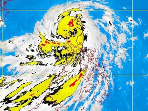
‘Pedring’ makes landfall on Aurora-Isabela border
MANILA, Philippines—Typhoon “Pedring” (international name: Nesat) made landfall at the boundary of Aurora and Isabela on Tuesday morning and will be at the vicinity of Baguio City in the afternoon, according to the Philippine Atmospheric, Geophysical and Astronomical Services Administration (Pagasa).
In its 5 a.m. bulletin, Pagasa raised Storm Signal No. 3 over Ilocos Norte, Ilocos Sur, Abra, Apayao, Kalinga, Mt. Province, Cagayan, Isabela, Ifugao, Benguet, La Union, Nueva Vizcaya, Quirino, Aurora, Nueva Ecija, Tarlac, Pangasinan and Zambales.
Signal No. 2 was still up over Metro Manila and the provinces of Pampanga, Bulacan, Bataan, Rizal, Northern Quezon (including Polillo Island), Cavite, Laguna, Batangas, Lubang Island, Calayan and the Babuyan Group of Islands.
Signal No. 1 was hoisted over Batanes, Oriental Mindoro, Occidental Mindoro, Marinduque, Burias Island, Camarines Norte, Camarines Sur, Albay, Southern Quezon, Catanduanes, Romblon, and the Calamian Group of Islands.
As of 4 a.m., Pedring was moving west northwest-ward at 19 kilometers per hour. It had maximum winds of 140 kph near the center and gustiness of 170 kph.
Residents living in low-lying and mountainous areas under storm signal warnings are alerted against possible landslides and flashfloods.
Article continues after this advertisementLikewise, Pagasa warned residents living along coastal areas against possible storm surges due to Pedring.
Article continues after this advertisementRainfall amount was estimated at 15-25 millimeters per hour within the 650 km diameter of the typhoon, the state-run weather bureau said.
Pedring is forecast to enhance the southwest monsoon and bring scattered to widespread rains over southern Luzon and Visayas.
“Northern and Central Luzon and Bicol region will experience stormy weather while the rest of Southern Luzon and Western Visayas will have rains with gusty winds. The rest of Visayas will have cloudy skies with scattered rainshowers and thunderstorms while Mindanao will be mostly cloudy with scattered rainshowers and thunderstorms,” Pagasa said.
Pagasa said that by Wednesday morning, Pedring will be at 150 km northwest of Sinait, Ilocos Sur and at 360 km northwest of Sinait, Ilocos Sur in the afternoon. It was expected to exit the Philippine area of responsibility by Wednesday evening.
For a related report, listen to Radyo Inquirer 990AM.
