‘Hagupit’ likely to hit land; critical areas identified

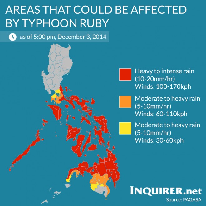
Areas that could be affected by typhoon Ruby (international name Hagupit) if it continues its westward movement. INQUIRER.net
MANILA, Philippines–The Philippine Atmospheric, Geophysical and Astronomical Services Administration (Pagasa) on Wednesday identified the critical areas likely to be affected by Typhoon “Hagupit” (local name: Ruby).
Jun Dalida, assistant director of Pagasa, said that based on current forecast models, there is a 75% chance of Hagupit making landfall in Eastern Visayas on Saturday and 25% of doing a recurve and sparing the Philippines and instead head towards southern Japan.
“Based on historical database of Pagasa in 67 years, tinignan natin lahat ng coordinate ng bagyong tumama kung saan nagsimula ang bagyong Hagupit, nakikita na sa karamihan ng bagyo na nag-form dyan sa coordinates na yan halos lahat ay tumama sa kalupaan at makikita rin natin na may ibang bagyo na lumihis,” Dalida said.
A list of provinces that may be affected by the typhoon was given by the weather bureau at the National Disaster Risk Reduction and Management Council (NDRRMC) on Wednesday afternoon.
Areas in Alert Level C have a rainfall of 10-20 millimeters/hour, or heavy to intense rains and winds of 100-170 kilometers per hour. Part of its impact include heavy damage to agricultural; some large trees uprooted; moderate to heavy disruption of electrical power and communication services. Travel by land, sea and air is dangerous:
Article continues after this advertisement
3. Aklan
4. Albay
5. Antique
6. Biliran
7. Bohol
8. Bukidnon
9. Camarines Norte/ 10. Camarines Sur
11. Camiguin
12. Capiz
13. Catanduanes
14 .Cebu
15. Compostela Valley
16. Davao del Norte
17. Davao Oriental
18. Dinagat Islands
19. Eastern Samar
20. Guimaras
21. Iloilo
22. Lanao del Norte/ 23. Lanao del Sur
24. Leyte
25. Marinduque
26. Masbate
27. Misamis Oriental/ 28. Misamis Occidental
29. Northern Samar
30. Negros Occidental/ 31. Negros Oriental
32. Occidental Mindoro
33. Oriental Mindoro
34. Palawan
35. Quezon
36. Romblon
37. Samar
38. Siquijor
39. Sorsogon
40. Southern Leyte
41. Surigao del Norte/ 42. Surigao del Sur
43. Zamboanga del Norte/ 44. Zamboanga del Sur
Areas in Alert Level B have rains of 5-10mm/hr or moderate to heavy and winds of 60-110 kph. Its impacts include moderate damage to agriculture and travel by all types of air and sea vessels is risky.
45. Batangas
46. Davao del Sur
47. Laguna
48. Maguindanao
49. North Cotabato
50. Zamboanga Sibugay
Areas in Alert Level A have rains of 5-10mm/hr or moderate to heavy and winds of 30 to 60kph.
51. Cavite
52. Metro Manila
53. Rizal
54. Sultan Kudarat
55. Zamboanga City
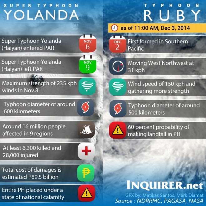
As of 5 p.m., Hagupit was spotted at 1,278 kilometers east of Hinatuan, Surigao del Sur. It gained more strength and packed maximum sustained winds of 160 kph near the center and gusts of up to 190 kph. It is forecast to move west northwest at 30 kph.
It will be locally named “Ruby” when it enters the Philippine area of responsibility on Thursday morning.
“Over water pa siya, before hitting land, pwede pa siya mag intensify pero hindi na n’ya kaya ma-attain ‘yung lakas ng Yolanda…pero malakas pa din ‘yun,” Dalida said.
At its peak, Supertyphoon “Yolanda” (Haiyan), which pummeled Eastern Visayas in November last year, was the strongest typhoon for 2013, packing maximum sustained winds of 235 kph with gusts of up to 275 kph.
RELATED STORIES
Pagasa: 60% chance ‘Hagupit’ will make landfall in Eastern Visayas
‘Yolanda’-like ‘Ruby’ heads for PH