Storm nearly 2,000-miles wide grounds some US flights

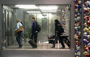
Passengers walk through Terminal 3 at O’Hare International Airport in Chicago on Saturday, Dec. 21, 2013. The National Weather Service issued a hazardous weather outlook for north central Illinois, northeast Illinois and northwest Indiana on Saturday morning. AP
CHICAGO — A storm with a 2,000-mile footprint frustrated Christmas travelers Saturday from Texas to Nova Scotia with a little of everything Mother Nature has to offer, from freezing rain, ice and snow to flooding, thunderstorms and even tornadoes.
Some of the millions of people who hit the roads and airports by midday Saturday squeaked through before any major weather had hit, but the cancellations and flight delays started to mount as the afternoon wore on.
Forecasters warned motorists that roads that seemed passable one minute could turn treacherous the next, as a cold blast on the storm’s back end turns rain to ice and snow.
The system’s strange swirl of winter and spring-like conditions produced starkly different weather at times in areas separated by a couple hundred miles. While drivers in Oklahoma and eastern Missouri were navigating ice-slicked streets Saturday, residents in Memphis, Tenn., were strolling around in T-shirts in spring-like temperatures in the mid-60s.
By Saturday night, a line of thunderstorms stretching from southern Louisiana to Indiana began wreaking havoc, causing rivers and creeks to swell, flooding roads and spawning winds strong enough to force cars and trucks off of highways. At least two suspected tornadoes touched down in Arkansas, injuring a total of five people and damaging nearly two-dozen homes in or near the towns of Dermott and Hughes. And a man in Rena Lara, Miss., was killed Saturday when wind flipped his mobile home.
Article continues after this advertisement“This is a particularly strong storm with very warm, near record-breaking temperatures in the East and very cold air in the Midwest, and that contrast is the sort of conditions that are favorable for not only winter weather but also tornadoes,” said National Weather Service meteorologist Ed Danaher in College Park, Md.
Article continues after this advertisementThe worst of the storm wasn’t supposed to hit Chicago until late Saturday or early Sunday, giving those traveling to, from or through the Windy City a window at the start of the holiday rush.
Nationwide, nearly 500 flights had been canceled Saturday and more than 7,000 were delayed as of 11 p.m. CST Saturday, according to aviation tracking website FlightAware.com. Most of the disruptions were affecting flights in and out of airports that serve as major hubs, including Chicago’s O’Hare, Houston’s Bush International, Dallas/Fort Worth and Denver International.
Given the potential problems with flying and driving, some travelers opted for rail.
Darren Hall, 45, of Raymore, Mo., normally drives to St. Louis for the holiday, but decided not to risk it because of the freezing rain hitting the area and the promise of worse to come. Instead, he was waiting for a train at Kansas City’s Union Station.
“You don’t have to deal with all the roads. It’s safer, less hassle,” Hall said.
Freezing rain coated parts of northern New England Saturday night, as officials warned people to stay off the roads and utilities prepared for the possibility of widespread power outages. Burlington, Vt., had received a quarter-inch of ice by late Saturday, and the city’s airport was forced to rely briefly on generators after losing power briefly.
“We’ve lined up hundreds of additional out-of-state line workers and tree trimmers in addition to all the GMP employees who will be working until all power is restored,” Vermont Green Mountain Power spokeswoman Dorothy Schnure said.
Many Midwest cities that spent Saturday dealing with rain and ice were expected to get significant snowfall overnight, with up to 6 inches forecast for the Kansas City area and up to 8 inches for southern Wisconsin, eastern Iowa and northwest Illinois.
In Indiana, the weather service posted flood warnings for Saturday along southern and central Indiana streams and predicted the highest flood crests along the East Fork of the White River since April 2011.
In addition to the Mississippi weather-related death, authorities in Oklahoma were blaming two traffic deaths on the rain and ice. A 16-year-old boy died early Saturday after his car crashed and overturned on U.S. 64 near Tulsa, according to the Oklahoma Highway Patrol. And Oklahoma City police said a woman was killed Friday night in a collision on a slick roadway.
If there is a silver lining for the estimated 94.5 million Americans who were planning to travel by road or air during this holiday season, which runs from Saturday through New Year’s Day, it’s that Christmas happens mid-week this year, AAA spokeswoman Heather Hunter said.
“When a holiday falls on a Wednesday it gives travelers more flexibility of either leaving the weekend before, or traveling right before the holiday and extending the trip through the following weekend,” Hunter said.
Related stories
US snow, ice storm cancels hundreds of flights
Massive winter storm grounds 1,200 US flights