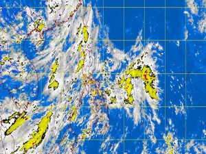
Rain in parts of PH due to LPA, ITCZ— Pagasa
MANILA, Philippines – A low pressure area and an intertropical convergence zone are bringing in rains in parts of the country, including Metro Manila, the state weather bureau said Monday.
Leny Ruiz, weather forecaster from the Philippine Atmospheric Geophysical and Astronomical Services Administration told INQUIRER.net that the LPA over Eastern Samar has chances of intensifying into a tropical depression and might make landfall.
The LPA was last observed 360 kilometers east of Guiuan, Eastern Samar. Should it intensify into a cyclone, it will be called “Isang.”
Meanwhile, the LPA was embedded along the intertropical convergence zone affecting Palawan, Visayas and Mindanao.
“Luzon, Visayas and the regions of Zamboanga Peninsula and Northern Mindanao will have cloudy skies with light to moderate rainshowers and thunderstorms,” Pagasa said.
Article continues after this advertisement“The rest of Mindanao will be partly cloudy to cloudy with isolated rainshowers or thunderstorms,” it added.
Article continues after this advertisementModerate to strong winds blowing from the southwest to southeast will prevail over the western section of Luzon and coming from the east to northeast over the rest of Luzon. The coastal waters along these areas, Pagasa said, will be moderate to rough.
Elsewhere, winds will be light to moderate coming from the west to southwest with slight to moderate seas, it also said.
