‘Lawin’ to stay within PAR until Saturday—Pagasa
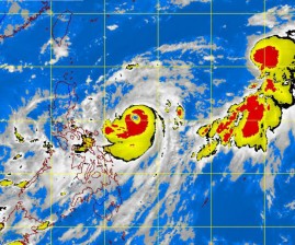
MANILA, Philippines—Typhoon Lawin (international name: Jelawat) is anticipated to stay within the country’s area of responsibility until the weekend after it further intensified and gained speed on Monday.
The Philippine Atmospheric, Geophysical and Astronomical Services Administration (Pagasa) has lifted the public storm warning signal over the Samar Provinces but warned that moderate to heavy rains over the MIMAROPA (Mindoro, Marinduque, Romblon, Palawan), the Bicol Region, the Visayas and Mindanao, except SOCCSKARGEN (South Cotabato, Cotabato, Sultan Kudarat, Saranggani, General Santos City) and the Davao region, may trigger flashfloods and landslides.
As of 10 a.m., on Monday, the eye of Lawin was estimated at 405 kilometers east of Virac, Catanduanes, with the typhoon packing maximum sustained winds of 185 kilometers per hour near the center and gustiness of up to 220 kilometers per hour as it continued to move north-northwest at a slow pace of seven kilometers per hour.
At 4 p.m., the typhoon was located based on satellite and surface data at 375 kilometers east of Virac, Catanduanes, slightly speeding up, moving north-northwest at nine kilometers per hour.
The estimated rainfall within the 700 kilometer-diameter of the typhoon is heavy to intense (10mm to 20 mm per hour) and Lawin is anticipated to enhance the habagat (southwest monsoon), which will continue to bring moderate to heavy rains in the Visayas and Mindanao.
Article continues after this advertisementWeather forecaster Adczar Aurelio told the Philippine Daily Inquirer that they saw the typhoon staying within the Philippine area of responsibility (PAR) until Saturday or Sunday because of its slow pace towards Taiwan or Basco, Batanes.
Article continues after this advertisementAurelio said that the low pressure area previously detected by the PAGASA, that might develop into a tropical depression upon entering the PAR, was still too far over the Pacific Ocean, as of Monday, to have any effect.
But should it develop into a tropical depression, it would be named “Marce” upon its entry into the PAR.
Metro Manila, CALABARZON (Cavite, Laguna, Batangas, Rizal, Quezon), Central Luzon and the rest of Mindanao will have occasional light to moderate rains and thunderstorms. The rest of Luzon will be partly cloudy with brief rainshowers or thunderstorms.
Moderate to strong winds blowing from the northeast to northwest will prevail over the Northern and Eastern Luzon and the Eastern Visayas and coming from the west to southwest over the rest of the Visayas and Mindanao. The coastal waters along these areas will be moderate to rough. Light to moderate winds coming from the northeast to northwest over the rest of Luzon with slight to moderate seas.
The weather bureau advised fishing boats and other small seacraft against venturing out into the eastern seaboards of Luzon, and the seaboards of the Visayas and Mindanao due to big waves generated by Lawin.
PAGASA, likewise, advised the public and the local disaster coordinating councils to take appropriate action.
