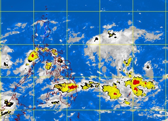
Visayas, Mindanao to experience rains, thunderstorms under ITCZ
MANILA, Philippines — With the Intertropical Convergence Zone (ITCZ) in effect over the Visayas and Mindanao, rainshowers and thunderstorms are to be expected in the regions.
The Philippine Atmospheric, Geophysical and Astronomical Services Administration (Pagasa) further said that despite a developing El Niño phenomenon in the Pacific, three to four tropical cyclones have been anticipated to enter the Philippine Area of Responsibility (PAR) this September.
The weather bureau, in its 5 p.m. forecast stated on Sunday, that Palawan, the Visayas and the northern section of Mindanao would have mostly cloudy skies with scattered rainshowers and thunderstorms because of the ITCZ.
Pagasa forecaster Fernando Cada told the Philippine Daily Inquirer that the rest of the country, including Metro Manila, would have generally good weather except for possible rains later in the day. The areas are forecast to be partly cloudy to cloudy with isolated rainshowers or thunderstorms mostly in the afternoon or evening.
Cada said the ITCZ has been the dominant weather system affecting the country and the weather bureau has not detected any other weather system.
Article continues after this advertisementAccording to the weather forecasters, the ITCZ is virtually a transition period from the habagat (southwest monsoon) and the amihan (northeast monsoon), which annually sets in on September and is basically a merger of winds that causes cloud formations that bring the thunderstorms.
Article continues after this advertisementThe Pagasa 5 pm forecast further stated that moderate-to-strong winds blowing from the southeast would prevail over Northern Luzon and its coastal waters would be moderate to rough. Elsewhere, light to moderate winds coming from the southwest to southeast will prevail and the coastal waters along these areas will be slight to moderate.
Meanwhile, Cada told the Philippine Daily Inquirer that three to four tropical cyclones have been anticipated to enter the PAR within September despite the developing El Niño phenomenon in the central equatorial Pacific Ocean.
“We still expect three to four cyclones to enter the PAR this month although low pressure areas (LPAs) tend to dissipate quickly because of the developing El Niño phenomenon and their proximity to land mass within the PAR when they develop,” Cada explained.
Based on reports from the Pagasa Climatology and Agrometeorology Division (CAD), there were indicators that the phenomenon, once full-blown, would affect areas in the country, particularly the Central Visayas and Northern Mindanao by the end of the year.
The agency’s CAD noted that there was below normal rainfall in Tagbilaran, Bohol Province, last month where the average rainfall in previous years for August was at 100 mm per hour. Last month, the weather bureau recorded the rainfall at 6.8 mm per hour in the area. Cada called it an indicator of drought but it was not conclusive yet. “(T)hat cannot be considered a drought yet because technically, the conditions of below normal rainfall should persist for three months,” Cada said.
