Marce gains strength; heavy rainfall forecast in Northern Luzon

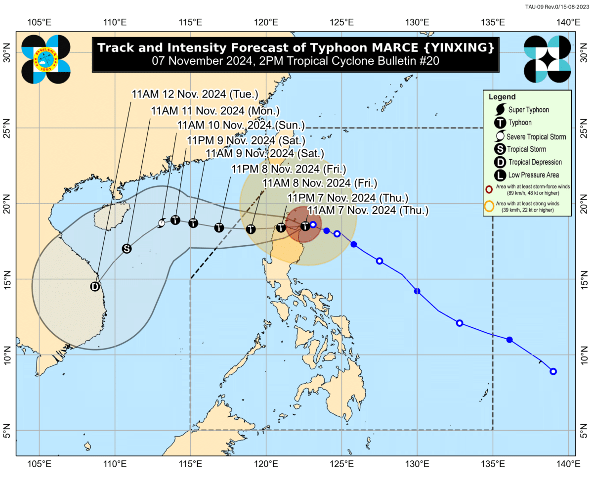
Track of Typhoon Marce. Image from Pagasa.
MANILA, Philippines — Heavy rainfall is expected in Northern Luzon as Typhoon Marce (international name: Yinxing) intensified while approaching northeastern Cagayan on Thursday afternoon, the Philippine Atmospheric, Geophysical, and Astronomical Services Administration (Pagasa) said.
In its 2 p.m. bulletin, Pagasa said Marce’s eye was spotted over the coastal waters of Santa Ana, Cagayan. It was packing maximum sustained winds of 175 kilometers per hour (kph) and a gustiness of up to 240 kph. It was moving west-northwestward at 10 kph.
Strong to typhoon-force winds may also extend outwards up to 560 kilometers from the typhoon’s center, according to Pagasa.
Given such developments, the state weather bureau issued a heavy rainfall outlook for 12 Northern Luzon provinces.
Pagasa said intense torrential rains greater than 200 millimeters are expected in Cagayan, Ilocos Norte, and Apayao areas.
Article continues after this advertisementHeavy to intense rains ranging from 100 to 200 mm are expected in Batanes, Ilocos Sur, Isabela, and Abra.
Article continues after this advertisementModerate to heavy rains of 50 to 100 mm may affect La Union, Kalinga, Mountain Province, Benguet, and Ifugao.
Pagasa also said Tropical Cyclone Wind Signals (TCWS) No. 4 is currently raised over the following areas:
- Northern portion of Cagayan (Gonzaga, Santa Ana, Santa Teresita, Lal-Lo, Buguey, Aparri, Camalaniugan, Gattaran, Ballesteros, Allacapan, Abulug, Pamplona, Sanchez-Mira, Claveria, Santa Praxedes, Lasam) including Babuyan Islands
- Northern portion of Apayao (Santa Marcela, Luna, Flora, Calanasan, Pudtol)
- Northern portion of Ilocos Norte (Pagudpud, Bangui, Vintar, Dumalneg, Adams, Bacarra, Pasuquin, Burgos)
In areas under TCWS No. 4, winds of greater than 118 kph up to 184 kph may be expected in the next 12 hours.
Meanwhile, TCWS No. 3 was hoisted over the following:
- Batanes
- The rest of Cagayan
- The rest of Apayao
- The est of Ilocos Norte
- Northern portion of Abra (Tineg, Danglas, Lagayan, Lacub, San Juan, La Paz, Bangued)
- Northern portion of Ilocos Sur (Sinait, Cabugao, San Juan, Magsingal, Santo Domingo)
Areas under TCWS No. 3 may expect winds stronger than 89 kph to 117 kph in at least 18 hours.
Pagasa also placed the following areas under TCWS No. 2:
- Northern and central portions of Isabela (San Pablo, Santa Maria, Divilacan, Tumauini, Maconacon, Cabagan, Santo Tomas, Quezon, Palanan, Ilagan City, Mallig, Delfin Albano, Quirino, San Mariano, Gamu, Roxas, Naguilian, Burgos, Reina Mercedes, Benito Soliven, Luna, Aurora, San Manuel, San Mateo, Alicia, Angadanan, City of Cauayan, Cabatuan)
- The rest of Abra
- Kalinga
- Mountain Province
- Northern portion of Ifugao (Alfonso Lista, Aguinaldo, Mayoyao, Banaue, Hungduan)
- Northern portion of Benguet (Bakun, Mankayan)
- The rest of Ilocos Sur
- Northern portion of La Union (Sudipen, Bangar, Balaoan, Luna, Santol)
Winds of greater than 62 kph to 88 kph are possible in areas under TCWS No. 2 in at least 24 hours.
Meanwhile, the following areas were placed under TCWS No. 1, where winds of 39 to 61 kph may be expected in the next 36 hours:
- The rest of La Union
- Pangasinan
- The rest of Ifugao
- The rest of Benguet The rest of Isabela
- Quirino
- Nueva Vizcaya
- The northern and central portions of Aurora (Dilasag, Casiguran, Dinalungan, Dipaculao, Maria Aurora, Baler) The northern portion of Nueva Ecija (Carranglan)
- The northern portion of Zambales (Santa Cruz, Candelaria)
Pagasa also issued a gale warning over the seaboards of Northern Luzon and Central Luzon, which means sea travel is deemed for all types of vessels.
READ: Marce nears Cagayan, to make landfall within hours – Pagasa