Marce nears Cagayan, to make landfall within hours – Pagasa

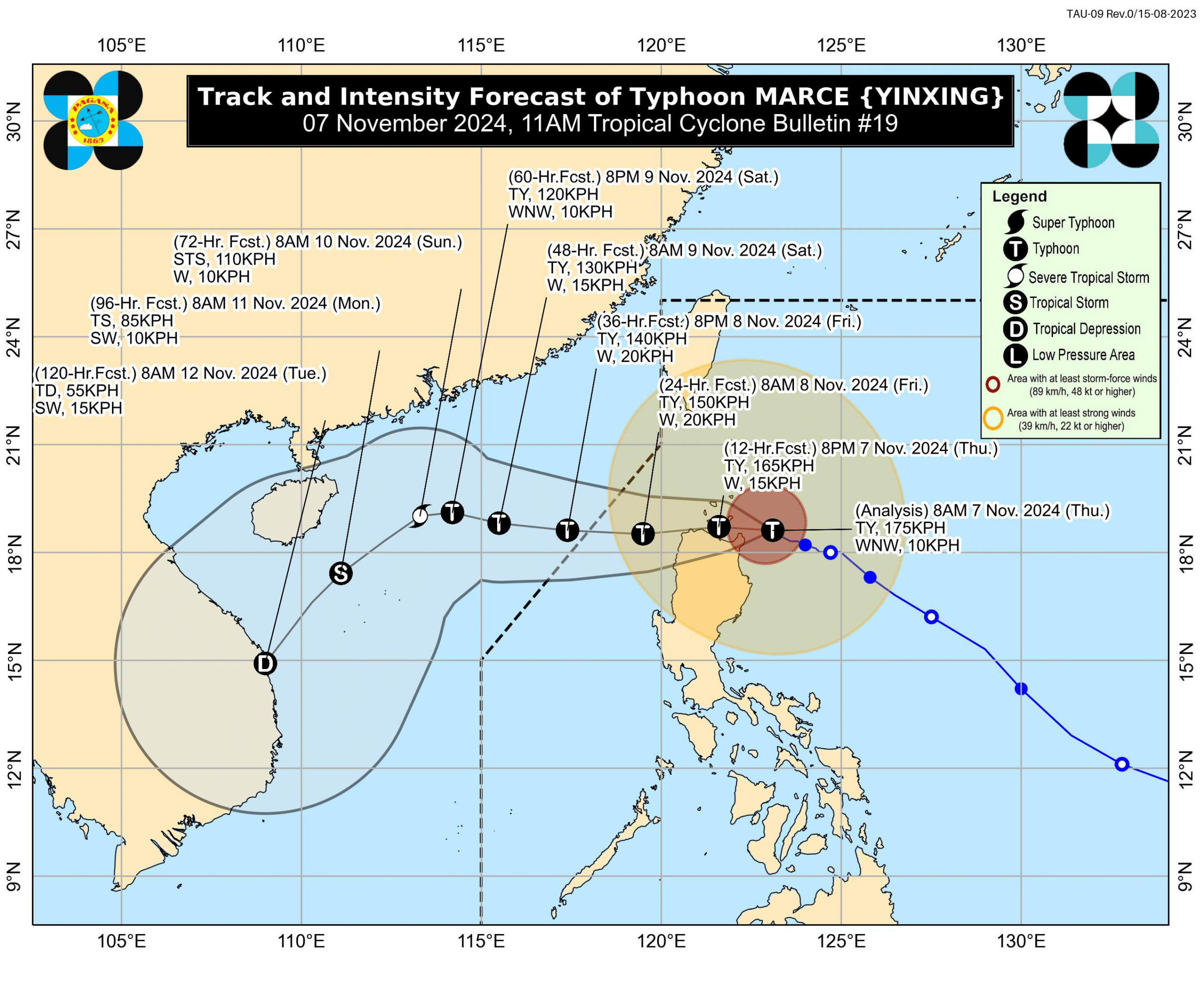
Track and intensity forecast of Typhoon Marce (international name: Yinxing) as of 11 a.m. Thursday, November 7, 2024. (Photo by Pagasa/Facebook)
MANILA, Philippines — Typhoon Marce (international name: Yinxing) is approaching northeastern Cagayan and will likely make landfall by Thursday afternoon or Friday early morning, the state weather agency said.
In its 11 a.m. typhoon bulletin, the Philippine Atmospheric, Geophysical and Astronomical Services Administration (Pagasa) said that Marce “will make a landfall and traverse the Babuyan Islands and/or the northern portions of mainland Cagayan, Ilocos Norte, and Apayao.”
Pagasa noted that these areas will experience “potentially life-threatening conditions due to typhoon-force winds, storm surge inundation, and torrential rainfall.”
READ: Signal No. 4 in 3 Northern Luzon areas as Typhoon Marce strengthens
Typhoon Marce was last located 115 kilometers east of Aparri, Cagayan, moving west-northwestward at 10 kilometers per hour (kph). It was carrying maximum sustained winds of 175 kph and gustiness of up to 215 kph.
As of the newest typhoon update, Pagasa issued Tropical Cyclone Wind Signals (TCWS) in the following areas:
TCWS No. 4
- The northern portion of mainland Cagayan (Gonzaga, Santa Ana, Santa Teresita, Lal-Lo, Buguey, Aparri, Camalaniugan, Gattaran, Ballesteros, Allacapan, Abulug, Pamplona, Sanchez-Mira, Claveria, Santa Praxedes, Lasam) including the Babuyan Islands
- The northeastern portion of Apayao (Santa Marcela, Luna, Flora, Calanasan, Pudtol)
- Northern portion of Ilocos Norte (Pagudpud, Bangui, Vintar, Dumalneg, Adams, Bacarra, Pasuquin, Burgos)
TCWS No. 3
- Batanes
- Rest of Cagayan
- Rest of Apayao
- Rest of Ilocos Norte
- Northern portion of Abra (Tineg, Danglas, Lagayan, Lacub, San Juan, La Paz, Bangued)
- Northern portion of Ilocos Sur (Sinait, Cabugao, San Juan, Magsingal, Santo Domingo)
READ: Marce keeps peak power off Cagayan; 2 areas under Signal No. 4
TCWS No. 2
- Northern and central portions of Isabela (San Pablo, Santa Maria, Divilacan, Tumauini, Maconacon, Cabagan, Santo Tomas, Quezon, Palanan, Ilagan City, Mallig, Delfin Albano, Quirino, San Mariano, Gamu, Roxas, Naguilian, Burgos, Reina Mercedes, Benito Soliven, Luna, Aurora, San Manuel, San Mateo, Alicia, Angadanan, City of Cauayan, Cabatuan)
- Rest of Abra
- Kalinga
- Mountain Province
- Northern portion of Ifugao (Alfonso Lista, Aguinaldo, Mayoyao, Banaue, Hungduan)
- Northern portion of Benguet (Bakun, Mankayan)
- Rest of Ilocos Sur
- Northern portion of La Union (Sudipen, Bangar, Balaoan, Luna, Santol)
TCWS No. 1
- Rest of La Union
- Pangasinan
- Rest of Ifugao
- Rest of Benguet
- Rest of Isabela
- Quirino
- Nueva Vizcaya
- Northern and central portions of Aurora (Dilasag, Casiguran, Dinalungan, Dipaculao, Maria Aurora, Baler)
- Northern portion of Nueva Ecija (Carranglan)
- Northern portion of Zambales (Santa Cruz, Candelaria)
Also due to Marce, Pagasa hoisted a gale warning over the seaboards of Northern Luzon and Central Luzon.
Pagasa said Marce will exit the Philippine area of responsibility by Friday afternoon or evening.