Marce keeps peak power off Cagayan; 2 areas under Signal No. 4

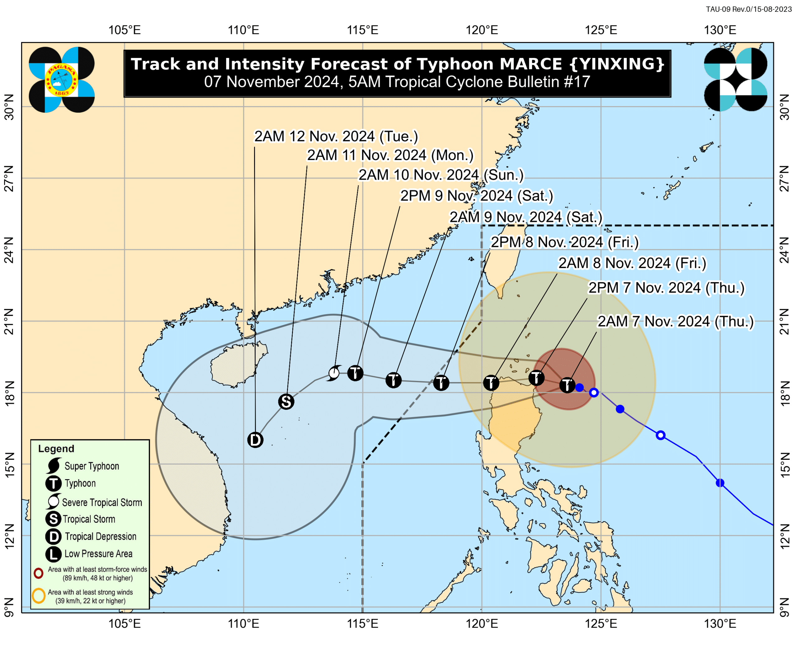
The latest track and intensity forecast for Typhoon Marce (international name: Yinxing). Photo courtesy of DOST / Pagasa
MANILA, Philippines — Typhoon Marce (international name: Yinxing) maintained its peak intensity as it moved west-northwest over the waters of Cagayan, the Philippine Atmospheric, Geophysical, and Astronomical Services Administration (Pagasa) reported Thursday morning.
In a 5 a.m. bulletin, Pagasa said Marce was last spotted 200 kilometers (km) east of Aparri, Cagayan, packing maximum sustained winds of 155 kilometers per hour (kph) and gusts of 190 kph.
“In terms of intensity, it will remain strong or still within the typhoon category. It is now at its peak intensity of around 155 kph. It will slightly weaken while here at the northern tip of mainland Luzon and eventually, upon exiting the Philippine area of responsibility (PAR), it will further weaken into a severe tropical storm,” Pagasa weather specialist Benison Estareja explained in a mix of Filipino and English during a briefing.
READ: LIST: Luzon areas to have moderate to torrential rains from Nov. 6-8
Estareja noted that weather satellite data indicates the typhoon’s extensive radius, spanning approximately 900 to 1,000 km in diameter, which means the effects of Typhoon Marce may be felt in other parts of Luzon, such as Aurora province.
“The strongest winds remain concentrated near the storm’s eye, so we can still expect severe weather conditions within 24 hours in many areas of Cagayan, Apayao, and Ilocos Norte,” he also said in mixed Filipino and English.
Due to these developments, Pagasa raised Tropical Cyclone Wind Signal (TCWS) No. 4 in the following areas:
- Northern portion of mainland Cagayan (Gonzaga, Santa Ana, Santa Teresita, Lal-Lo, Buguey, Aparri, Camalaniugan, Gattaran, Ballesteros, Allacapan, Abulug, Pamplona, Sanchez-Mira) including Babuyan Islands
- Northeastern portion of Apayao (Santa Marcela)
Areas under TCWS No. 4 are likely to experience winds ranging from 118 kph to 184 kph within 12 hours.
Pagasa also placed the following areas under TCWS No. 3:
- Southern portion of Batanes (Mahatao, Uyugan, Basco, Ivana, Sabtang)
- The rest of Cagayan
- The rest of Apayao
- Ilocos Norte
- Northern portion of Abra (Tineg)
Areas under TCWS No. 3 may expect winds stronger than 89 kph to 117 kph in at least 18 hours.
The state weather service hoisted TCWS No. 2 over:
- The rest of Batanes
- Northern and central portions of Isabela (San Pablo, Santa Maria, Divilacan, Tumauini, Maconacon, Cabagan, Santo Tomas, Quezon, Palanan, Ilagan City, Mallig, Delfin Albano, Quirino, San Mariano, Gamu, Roxas, Naguilian, Burgos, Reina Mercedes, Benito Soliven, Luna, Aurora, San Manuel, San Mateo, Alicia, Angadanan, City of Cauayan, Cabatuan)
- The rest of Abra
- Kalinga
- Mountain Province
- Northern portion of Ifugao (Alfonso Lista, Aguinaldo, Mayoyao, Banaue, Hungduan)
- Northern portion of Benguet (Bakun, Mankayan)
- Ilocos Sur
- Northern portion of La Union (Sudipen, Bangar, Balaoan, Luna, Santol)
Winds of greater than 62 kph to 88 kph are possible in areas under TCWS No. 2 in at least 24 hours.
READ: Gov’t on ‘high alert’ for Marce impact
Lastly, Pagasa declared TCWS No. 1 over the following areas due to Typhoon Marce:
- The rest of La Union
- Pangasinan
- The rest of Ifugao
- The rest of Benguet
- The rest of Isabela
- Quirino
- Nueva Vizcaya
- Northern and central portions of Aurora (Dilasag, Casiguran, Dinalungan, Dipaculao, Maria Aurora, Baler)
- Northern portion of Nueva Ecija (Carranglan)
- Northern portion of Zambales (Santa Cruz, Candelaria)
These places could see intermittent rains and winds of 39 kph to 61 kph within 36 hours.
The latest development on Marce also prompted Pagasa to raise a gale warning over the seaboards of Northern Luzon and Central Luzon.
Pagasa said Typhoon Marce is expected to continue moving west-northwest over the waters east of Cagayan for the next 12 hours and then shift direction to a generally westward track from Thursday afternoon until Saturday, Nov. 9.
“On the forecast track, Marce will make landfall and traverse Babuyan Islands and/or the northern portions of mainland Cagayan, Ilocos Norte, and Apayao (or pass very close to these areas) from this afternoon (November 7) until tomorrow (8 November) early morning,” Pagasa said in its 5 a.m. bulletin.
Marce is anticipated to leave the PAR by Friday evening, it added.


