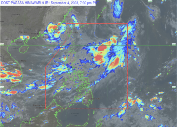
LPA forms inside PAR, to become 1st tropical cyclone in September

Source: DOST / Pagasa
MANILA, Philippines — The cloud clusters inside the Philippine area of responsibility off extreme northern Luzon developed into a low pressure area (LPA) on Monday, state meteorologists said.
And this LPA will also become the first tropical cyclone for the month of September, according to Benison Estareja, weather specialist of the Philippine Atmospheric, Geophysical and Astronomical Services Administration (Pagasa).
“Isang low pressure area po ang ating mino-monitor sa loob ng Philippine area of responsibility. Ito ‘yung cloud clusters na ating mino-monitor nitong mga nagdaang araw,” Estareja said in a public weather forecast.
(Another low pressure area is being monitored inside the Philippine area of responsibility. These were the cloud clusters that we were monitoring in the previous days.)
Estareja said this LPA has been spotted 870 kilometers east of extreme northern Luzon and will soon develop into a tropical depression.
Article continues after this advertisement“Base po sa ating analysis possible po itong maging isang tropical depression or mahinang bagyo sa susunod na 24 oras,” he also said.
Article continues after this advertisement(Based on our analysis, this could become a tropical depression or a weak tropical cyclone in the next 24 hours.)
Once developed, this tropical depression will be called “Ineng,” the ninth tropical cyclone this year.
Meanwhile, this LPA and the Severe Tropical Storm Haikui (formerly Hanna) is strengthening the southwest monsoon or habagat, bringing rains in most parts of Luzon and Visayas, according to Estareja.
RELATED STORIES:
Hanna leaves PAR; Batanes wind signal lifted, but habagat persists – Pagasa
NDRRMC: 500K people now affected by Hanna, Goring, southwest monsoon