‘Florita’ slightly weakens, may exit PH on Wednesday – Pagasa
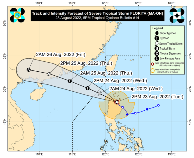
Track of severe tropical storm Florita (international name: Ma-on) from Pagasa
MANILA, Philippines —The “frictional effects of rugged terrain” caused severe tropical storm Florita (international name: Ma-on) to weaken slightly on Tuesday afternoon as it crossed Northern Luzon, likely exiting the Philippine Area of Responsibility (PAR) by Wednesday morning.
The Philippine Atmospheric Geophysical and Astronomical Services Administration (Pagasa) issued these updates in its 5 p.m. cyclone bulletin, which placed Florita in the vicinity of Kabugao, Apayao while packing maximum sustained winds of 100 kilometers per hour (kph) near the center with gustiness of up to 165 kph.
According to the state weather bureau, Florita’s path was northwestward or west-northwestward and is seen to cross the northern portions of Apayao and Ilocos Norte before exiting PAR on Wednesday morning.
“The frictional effects of the rugged terrain of Northern Luzon will cause ‘Florita’ to slightly weaken,” Pagasa said in its latest forecast.
“Once over the West Philippine Sea, the tropical cyclone is forecast to re-intensify and may reach typhoon category by Wednesday afternoon,” it added.
Article continues after this advertisementPagasa also warned in its 5 p.m. bulletin that Florita may cause winds of storm-force in strength in areas where Tropical Cyclone Wind Signal (TCWS) No. 3 is hoisted while winds may reach gale-force in strength in any of the places where TCWS No. 2 is hoisted.
Article continues after this advertisementIt also said Florita would have strong winds with a strong breeze to near gale strength in any areas where TCWS No. 1 is currently in effect.
The state weather bureau explained that strong-force wind could pose moderate to significant threat to life and property; gale-force wind, minor to moderate threat to life and property; and strong breeze to near gale wind, minimal to minor threat to life and property.
Areas under TCWS No. 3, where storm-force winds may prevail within 18 hours, are: Ilocos Norte, Apayao, the southern portion of Babuyan Islands (Camiguin Is., Fuga Is., Dalupiri Is.), and mainland Cagayan.
Areas under TCWS No. 2, where gale-force winds may occur within 24 hours, are: Ifugao, Mountain Province, Kalinga, Abra, Ilocos Sur, Isabela, and the rest of Babuyan Islands.
Meanwhile, below are the areas under TCWS No. 1, where strong winds may be anticipated within 36 hours:
- La Union
- the eastern portion of Pangasinan (Umingan, San Fabian, Sison, Pozorrubio, San Jacinto, Laoac, Binalonan, San Manuel, Asingan, Tayug, Santa Maria, San Quintin, Natividad, San Nicolas)
- Benguet
- Nueva Vizcaya
- Quirino
- the northern portion of Nueva Ecija (Carranglan, Lupao, San Jose City, Pantabangan)
- the northern and central portions of Aurora (Maria Aurora, Dipaculao, Dinalungan, Casiguran, Dilasag)
RELATED STORY
Signal No. 3 raised in several areas as ‘Florita’ intensifies into a severe tropical storm