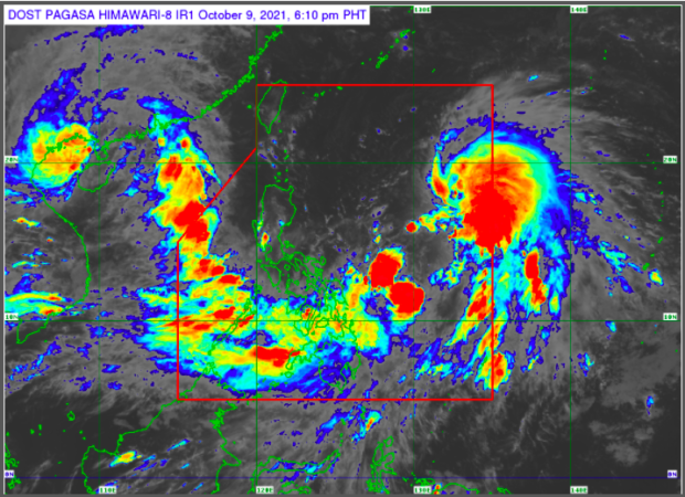
Maring may intensify; possible merger with another typhoon likely — Pagasa
MANILA, Philippines — Tropical Storm (TS) Maring may become a severe tropical storm as it interacts with the circulation of Tropical Depression (TD) Nando, the state weather bureau said on Saturday.
In its 5 p.m. bulletin, Pagasa said Maring will “persist” in a possible merger with “Nando” as both weather disturbances are presently embedded within the larger circulation of a monsoon depression. The merging of two will occur within 24 hours.
“The resulting merger cyclone is forecast to continue intensifying within the forecast period and may reach severe tropical storm category within 36 hours,” the bureau added.
The center of TS Maring is estimated to be at 745 kilometers east of Catarman, Northern Samar, packing maximum sustained winds of 85 kilometers per hour (kph) with gustiness of up to 105 kph.
TD Nando, on the other hand, is estimated to be at 895 km east of Central Luzon, with maximum sustained winds of 45 kph, with gustiness of up to 55 kph, moving west southwestward.
Article continues after this advertisement“Afterwards, the resulting merger, likely dominated by Maring, is forecast to move generally west northwestward until Monday before turning westward by Tuesday,” Pagasa said.
Article continues after this advertisementPagasa said the storm will cross the Luzon Strait and pass close to Batanes and Babuyan Islands within Monday or Tuesday.
Meanwhile, parts of Luzon and the entire Visayas and Mindanao will experience rainy weather due to TS Maring.
READ: Parts of Luzon, entire VisMin to experience rainy weather due to Maring
TROPICAL CYCLONE BULLETIN NO.9
Tropical Storm “#MaringPH” (KOMPASU)
Issued at 5PM 09 Oct 2021
Valid for broadcast until the next bulletin at 11PM todayTROPICAL STORM “MARING” MAINTAINS ITS STRENGTH AS IT INTERACTS WITH THE CIRCULATION OF “NANDO”
Link: https://t.co/nOU97294Wi pic.twitter.com/oc6GZ10esP
— PAGASA-DOST (@dost_pagasa) October 9, 2021
