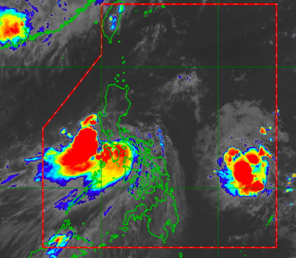
Tropical Storm Dante maintains strength, now over Oriental Mindoro coastal waters
MANILA, Philippines — Tropical Storm Dante was able to maintain its strength as of Wednesday afternoon as it moves along the coastal waters of Calapan, Oriental Mindoro, state meteorologists said.
According to the latest severe weather bulletin from the Philippine Atmospheric, Geophysical and Astronomical Services Administration (Pagasa), Dante still packs maximum sustained winds of 65 kilometers per hour (kph) near the center and gustiness of up to 90 kph.
It is still moving on a west-northwestward pattern at a speed of 15 kph.
As of now, Tropical Cyclone Wind Signal No. 2 is still raised over the following areas:
northern and central portion of Oriental Mindoro (Roxas, Bongabong, San Teodoro, Puerto Galera, Baco, City of Calapan, Naujan, Victoria, Socorro, Pola, Pinamalayan, Gloria, Bansud)
northern and central portion of Occidental Mindoro (Sablayan, Santa Cruz, Paluan, Mamburao, Abra de Ilog) including Lubang Islands
Batangas
Cavite
Bataan
southwestern portion of Bulacan (Calumpit, Bulacan, City of Malolos, Paombong, Hagonoy)
western portion of Pampanga (Masantol, Macabebe, Sasmuan, Lubao, Floridablanca, Porac, Guagua, Santa Rita, Angeles City, Mabalacat City, Minalin, Bacolor)
Zambales
western portion of Tarlac (Bamban, Capas, San Jose, Mayantoc, Camiling, Santa Ignacia, San Clemente)
western portion of Pangasinan (Bolinao, Anda, Bani, Agno, Burgos, Infanta, Dasol, City of Alaminos, Mabini, Sual, Labrador, Bugallon, Aguilar, Mangatarem, Bayambang, Urbiztondo, Basista, Malasiqui, San Carlos City, Santa Barbara, Mangaldan, Dagupan City, Calasiao, Binmaley, Lingayen)
The following areas on the other hand are under Signal No. 1:
Article continues after this advertisementMarinduque
western portion of Romblon (Romblon, San Agustin, Santa Maria, Odiongan, Alcantara, Looc, Ferrol, Santa Fe, San Jose, San Andres, Calatrava, Corcuera, Banton, Concepcion)
the rest of Oriental Mindoro
the rest of Occidental Mindoro
western portion of Quezon (Sampaloc, Lucban, City of Tayabas, Dolores, Tiaong, San Antonio, Candelaria, Sariaya, Lucena City, Pagbilao, Padre Burgos, Agdangan, Atimonan, Unisan, Plaridel)
Laguna
Metro Manila
Rizal
the rest of Bulacan
the rest of Pampanga
the rest of Tarlac
western portion of Nueva Ecija (Science City of Muñoz, Lupao, Cuyapo, Talugtug, Guimba, Nampicuan, Quezon, Licab, Santo Domingo, Talavera, Cabanatuan City, Santa Rosa, Aliaga, Zaragoza, Jaen, San Antonio, Cabiao, San Isidro, San Leonardo, City of Gapan, Peñaranda)
the rest of Pangasinan
southern portion of Benguet (Itogon, Tuba, Sablan, Baguio City, La Trinidad, Kapangan, Tublay)
La Union
northwestern portion of Antique (Caluya)
Pagasa said that strong to gale-force winds are still possible over the areas under Signal No. 2, which may cause where light to moderate damage to structures and vegetation. Strong breeze to near gale on the other hand may be expected in areas under Signal No. 1
Earlier, Dante was reported to have made its sixth landfall, over Pola, Oriental Mindoro, at around 2:00 p.m. The numerous amount of landfalls runs contrary to Pagasa’s initial forecast track which showed that Dante would graze the eastern provinces of the country before recurving back to the Pacific Ocean.
The weather bureau expects Dante to continue moving west northwest, which means it may still make landfall over Bataan or Zambales in the coming hours. By 2:00 a.m. of Thursday, Dante would be in the vicinity of San Felipe, Zambales, and would have weakened to a tropical depression due to interaction with Central Luzon’s mountainous areas.
It would then move north northwest over the West Philippine Sea and hover around 135 kilometers west of Laoag, Ilocos Norte, by Thursday afternoon. It would be 270 kilometers west of Basco, Batanes, and then exit by Saturday as a low-pressure area by early Friday morning.
Pagasa said that moderate to heavy rains with heavy rains would be felt over Cavite, Batangas, Romblon, Marinduque, Occidental Mindoro, Oriental Mindoro, Bataan, Zambales, and Pangasinan in the coming hours.
During the same period, the rest of Central Luzon, the rest of Calabarzon, Metro Manila, the northern portion of Palawan, including Calamian, Cuyo, and Cagayancillo Islands, Aklan, and Antique would receive moderate to heavy rains.
Light to moderate with at times heavy rains, on the other hand, would prevail in Camarines Norte, Camarines Sur, La Union, Ilocos Sur, Mountain Province, Kalinga, Abra, Benguet, Nueva Vizcaya, Quirino, and the rest of Mimaropa.
Pagasa also reminded seafarers that sea travel remains risky in areas under Tropical Cyclone Wind Signal Nos. 1 and 2, as sea conditions would be rough to very rough in these areas.
