


Bising maintains strength, may pass near Cagayan Wednesday
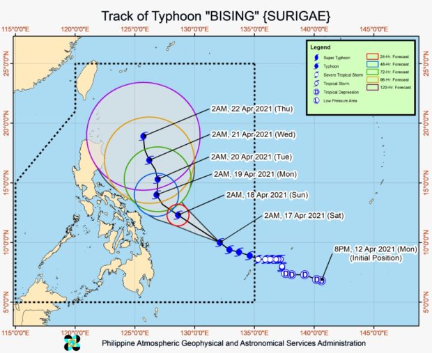
Latest track of typhoon Bising. Image from Pagasa
MANILA, Philippines — Typhoon Bising may pass closest to Cagayan Valley on Wednesday as the latest forecast track indicates that the weather disturbance may spend a longer time over the country’s eastern waters.
Bising was able to maintain its strength, packing maximum sustained winds of 195 kilometers per hour (kph) near the center and gusts of up to 240 kph according to weather updates from the Philippine Atmospheric, Geophysical and Astronomical Services Administration (Pagasa) on Monday afternoon.
The typhoon was last located 500 kilometers east of Infanta, Quezon province, and is currently moving north northwest slowly.
Bising is seen to continue its north northwest movement, which means that it would be around 465 kilometers east of Baler, Aurora by Tuesday afternoon. It would then be nearest to land on Wednesday afternoon, at 360 kilometers east of Tuguegarao City, Cagayan.
Only after Wednesday that Bising is expected to start recurving west, toward the Pacific Ocean. On Thursday, it may be around 370 kilometers east of Calayan, Cagayan, and 600 kilometers east of Itbayat, Batanes, by Friday afternoon.
Pagasa’s forecast track shows that Bising may maintain its typhoon category status even if there is a chance that it would slightly weaken while moving west. It is also not expected to hit land anymore, as the cone of uncertainty shows the nearest area that Bising could hit is the northernmost tip of Cagayan province.
From Monday afternoon to Monday night, moderate to heavy rains with at times intense rains will be felt in Bicol Region, Northern Samar, Samar, Eastern Samar, Biliran and the northern portion of Leyte.
Starting Tuesday, moderate to heavy rains will still occur over Bicol Region and Northern Samar, while light to moderate with at times heavy rains may prevail over the northern portion of Aurora and the eastern portions of mainland Cagayan and Isabela
“Under these conditions and considering the antecedent rainfall over the aforementioned areas, flooding (including flash floods) and rain-induced landslides are increasingly likely to occur especially in areas identified in hazard maps as highly or very highly susceptible to these hazards,” Pagasa said.
Tropical Cyclone Wind Signal No. 2 is still raised over the following areas:
Luzon
- Catanduanes
- Eastern portion of Camarines Sur (Siruma, Tinambac, Lagonoy, Garchitorena, Caramoan, Goa, Tigaon, San Jose, Presentacion, Sagnay, Buhi)
- Eastern portion of Albay (Tiwi, Malinao, Tabaco City, Malilipot, Santo Domingo, Bacacay, Rapu-Rapu, Legazpi City, Manito)
- Eastern and central portions of Sorsogon (Castilla, Sorsogon City, Prieto Diaz, Gubat, Barcelona, Casiguran, Juban, Magallanes, Bulan, Bulusan, Irosin, Santa Magdalena, Matnog)
Visayas
- Northern Samar
- Northern portion of Samar (Santo Nino, Almagro, Tagapul-An, Calbayog City, Santa Margarita, Gandara, Matuguinao, San Jose de Buan, San Jorge, Tarangnan,
- Pagsanghan, Catbalogan City, Paranas, Jiabong, Motiong, Hinabangan, San Sebastian)
- Northern portion of Eastern Samar (San Julian, Sulat, Taft, Can-Avid, Dolores, Maslog, Oras, San Policarpo, Arteche, Jipapad)
Pagasa said that areas under Signal No. 2 may experience wind speeds of 61 kph to 120 kph in the next 24 hours.
Other parts of the country are also under a Tropical Cyclone Wind Signal No. 1, which means that they may feel wind speeds of 30 kph to 60 kph in the next 36 hours:
Luzon
- Eastern portion of Cagayan (Lal-Lo, Gattaran, Alcala, Baggao, Amulung, Solana, Iguig, Tuguegarao City, Enrile, Peñablanca, Camalaniugan, Aparri, Buguey, Santa Teresita, Gonzaga, Santa Ana)
- Isabela
- Quirino
- Northern and central portions of Aurora (Baler, Dipaculao, Dinalungan, Casiguran, Dilasag)
- Eastern portion of Quezon (Calauag, Guinayangan, Tagkawayan, Buenavista, San Narciso, San Andres) including Polillo Islands
- Camarines Norte
- Rest of Camarines Sur,
- Rest of Albay
- Rest of Sorsogon
- Masbate including Burias and Ticao Islands
Visayas
- Rest of Samar
- Rest of Eastern Samar
- Biliran
- Leyte
- Northern portion of Cebu (Tabogon, Borbon, San Remigio, Bogo City, Medellin, Daanbantayan) including Bantayan and Camotes Islands
Pagasa reminded that no boats or sea crafts are allowed to set sail in areas under a tropical cyclone wind signal and a gale warning, which stretches from Ilocos Region’s waters to Cagayan Valley, down to Central Luzon, Southern Luzon, Bicol Region, Eastern Visayas’ waters, Central Visayas’ northern and eastern inland seas, and Caraga’s northern seaboards.


