Typhoon Tisoy intensifies, Signal No. 3 up in Catanduanes – Pagasa
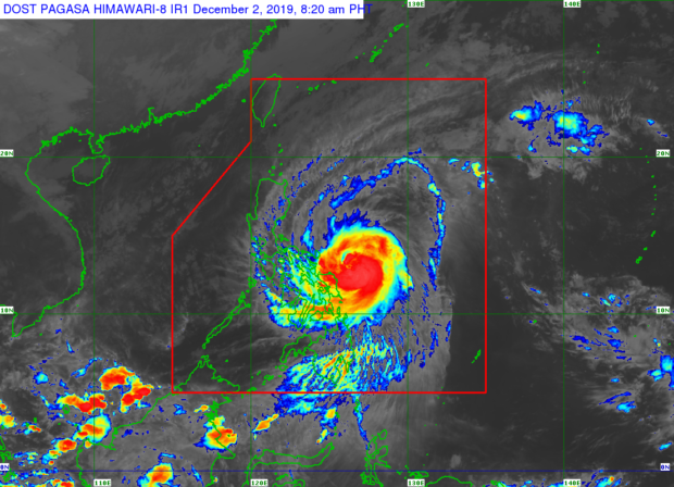
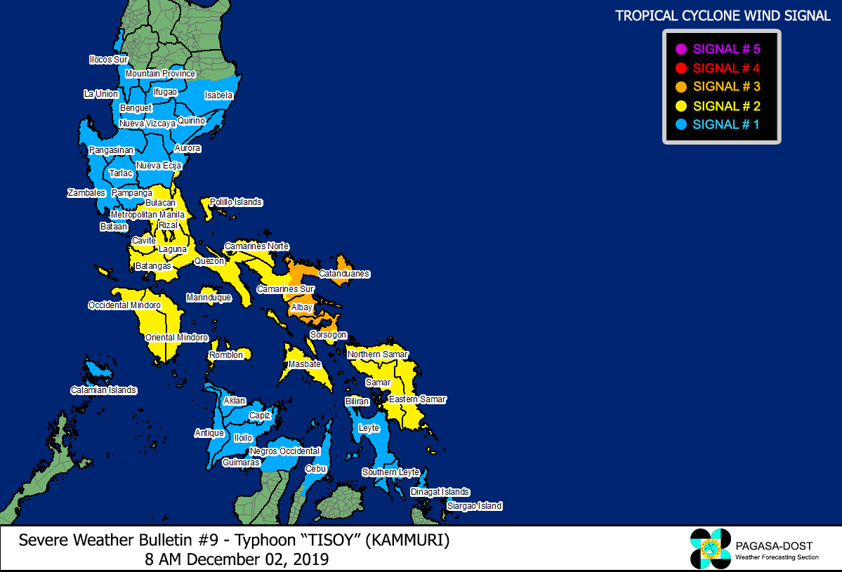
MANILA, Philippines — Tropical Cyclone Wind Signal (TCWS) No. 3 is now up over Catanduanes as Typhoon Tisoy (international name: Kammuri) slightly intensified, the state weather bureau said Monday morning.
TCWS No. 3 means that winds of greater than 121 kilometers per hour (kph) up to 170 kph may be expected in at least the next 18 hours, Philippine Atmospheric, Geophysical and Astronomical Services Administration (Pagasa) said.
In its 5 a. m. weather bulletin, Pagasa said Tisoy was last spotted 355 kilometers east of Virac, Catanduanes.
It has maximum sustained winds of 150 kilometers per hour (kph) with a gustiness of up to 185 kph and is expected to make landfall over Catanduanes or Albay between Monday night and early Tuesday morning.
Pagasa said intermittent to occasional heavy rains may prevail in the Bicol region, Eastern Visayas, northern Cebu, Dinagat Islands, and Siargao Island.
Article continues after this advertisementMeanwhile, frequent to continuous heavy to intense rains are expected in southern Quezon, and Marinduque.
Article continues after this advertisementFrom Monday afternoon to Tuesday noon, occasional heavy rains over Northern Samar, Romblon, Mindoro provinces, and the rest of Calabarzon is expected.
Intermittent heavy rains are also expected in Metro Manila, eastern portions of Cagayan and Isabela, and the rest of eastern Visayas.
Pagasa advised residents in the affected areas, especially those living in areas identified to be highly or very highly susceptible to flooding and rain-induced landslides, to take precautionary measures, coordinate with local disaster risk reduction and management offices, and continue monitoring weather updates.
As of 5 a.m., TCWS Signal No. 2 is up over:
* LUZON
Laguna
* Mabitac
* Santa Maria
* Famy
* Siniloan
* Pangil
* Paete
* Kalayaan
* Lumban
* Santa Cruz
* Pagsanjan
* Cavinti
* Pila
* Magdalena
* Luisiana
* Nagcarlan
* Liliw
* Majayjay
* Rizal
* San Pablo City
*Pakil
Batangas
*Padre Garcia
* Rosario
* Taysan
* Lobo
* San Juan
* Quezon including Polillo Islands
* Oriental Mindoro
* Marinduque
* Romblon
* Camarines Norte
* Camarines Sur
* Albay
* Sorsogon
* Masbate including Ticao and Burias Islands
* VISAYAS
* Northern Samar
* Eastern Samar
* Samar
* Biliran
Winds greater than 61 kph and up to 120 kph may be expected in at least the next 24 hours in areas placed under Signal No. 2, Pagasa noted.
Signal No. 1, which means winds of 30 to 60 kph may be expected in at least 36 hours or intermittent rains may be expected within 36 hours, is up in the following areas:
* LUZON
* Isabela
*Palanan
* Dinapique
* San Mariano
* San Guillermo
* Benito Soliven
* Naguilian
* Reina Mercedes
* Luna
* Aurora
* Cabatuan
* San Mateo
* Cauayan City
* Alicia
* Angadanan
* Ramon
* San Isidro
* Echague
* Cordon
* Santiago City
* Jones
*San Agustin
* Mountain Province
* Ifugao
* Benguet
* Nueva Vizcaya
* Ilocos Sur
* La Union
* Pangasinan
* Quirino
* Aurora
* Nueva Ecija
* Tarlac
* Pampanga
* Bulacan
* Zambales
* Bataan
* Metro Manila
* Rizal
* Cavite
* rest of Laguna
* rest of Batangas
* Occidental Mindoro
* Calamian Islands
* VISAYAS
* Aklan
* Capiz
* Antique
* Iloilo
* Guimaras
*Negros Occidental
*Bacolod City
* Bago City
* Cadiz City
* Calatrava
* Enrique B. Magalona
* Escalante City
* La Carlota City
* Manapla
* Murcia
* Pulupandan
* Sagay City
* Salvador Benedicto
* San Carlos City
* San Enrique
* Silay City
* Talisay City
* Toboso
* Valladolid
* Victorias City
*Cebu
*Daanbantayan
* Bantayan
* Madridejos
* Santa Fe
* Medellin
* Bogo City
* San Remigio
* Tabogon
* Tabuelan
* Borbon
* Sogod
* Catmon
* Asturias
* Metro Cebu
*Balamban
* Toledo City
* Pinamungahan
* Aloguinsan
* Naga City
* Talisay City
* Cordova
* Minglanilla
* Lapu-Lapu City
* Mandaue City
* Cebu City
* Consolacion
* Liloan
* Compostela
* Danao City
* Leyte
* Southern Leyte
* MINDANAO
* Dinagat Islands
*Siargao Island
The state weather bureau said one to three-meter storm surges may affect several coastal areas in Quezon, Camarines Norte, Camarines Sur, Catanduanes, and Samar.
Pagasa also warned of risky sea travel over the seaboards of areas with storm warning signals, the seaboards of Northern Luzon, the western seaboard of Palawan, central seaboards of Visayas, and the northern and eastern seaboards of Mindanao “due to prevailing or forecast rough sea conditions which may be perilous for maritime activities, especially for those using small seacraft.”
Gusty conditions may also prevail over areas in northern Luzon that are not under storm warning signals, especially in the coastal and mountainous zones due to the northeast monsoon or “amihan,” Pagasa added.

