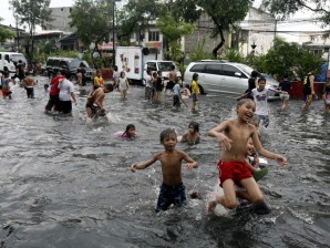
Children play in floodwaters following a sudden downpour that inundated low-lying areas in Manila. Typhoon Chedeng. AP/Bullit Marquez
MANILA, Philippines—(UPDATE) All storm warning signals were lifted as Chedeng left the country Saturday, but the rains continued to pour because of the southwest monsoon.
The Philippine Atmospheric, Geophysical and Astronomical Services Administration said in its 5 p.m. bulletin that Chedeng accelerated as it moved away from the Philippine area of responsibility.
Chedeng was moving northeast at 32 kilometers per hour, and had maximum sustained winds of 140 kilometers per hour near the center and gustiness of up to 170 kilometers per hour.
Chedeng was moving toward Japan and was expected to be 150 kilometers north of Okinawa, or 870 kilometers north northeast of Basco, Batanes, by Sunday morning.
But while Chedeng has left, several provinces in the country continued to be beset by rains because the typhoon strengthened the southwest monsoon, Pagasa said. Luzon, including Metro Manila, and Western Visayas were the most affected areas.
Mindanao, on the other hand, would be mostly cloudy with scattered rainshowers and thunderstorms.
Pagasa said the seas in Luzon and Western Visayas would be rough to very rough because of the monsoon rains, and advised precaution.
More storms are expected to hit the country now that the rainy season has arrived.
The weather bureau earlier said that it expects 18 to 21 tropical cyclones to enter the country, which is more than 11 last year. Two to three typhoons are expected in June.