Boracay at crossroads: Tourism or land reform

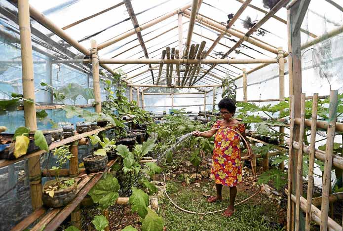
GREENHOUSE GARDEN Ati village chief Delza Supetron Justo, 66, helps grow vegetables in the community greenhouse garden in Boracay. The government plans to distribute farm lots to the indigenous people on the island. —LYN RILLON
(Last of two parts)
When President Rodrigo Duterte announced that he would place Boracay under land reform, many residents and property owners on the world-famous resort island were incredulous.
With most of the island developed for commercial and residential purposes amid unresolved land ownership issues, land reform was the last thing many expected to happen on the 1,032-hectare island.
Undersecretary David Erro, spokesperson for the Department of Agrarian Reform (DAR), announced on June 4 that the government’s land distribution plan would cover a total of 868 hectares in Boracay.
Three phases
Article continues after this advertisementUnder a draft executive order, which will serve as the legal basis of the DAR to distribute land in Boracay, agrarian reform will be implemented in three phases.
Article continues after this advertisementThe first phase will cover 25 ha that are free of structures and ready for immediate distribution. The parcels of land are in Barangays Yapak (14 ha), Manoc-Manoc (10 ha) and Balabag (1 ha).
The second phase will cover 220 ha, including parcels of land with existing structures, which, according to Erro, will have to be removed trough legal action.
The third phase will cover 623 ha of agricultural land.
“If possible, we can have Atis as the [immediate] beneficiaries. Give them training so . . . they themselves will supply the [agricultural] needs of Boracay,” Erro said.
State-owned
The draft executive order, prepared by the DAR, was ready for submission to the President for his signature.
Erro said identification of these areas for land reform coverage was premised on the classification of lands as state-owned (except the titled areas).
DAR officials earlier said that land earmarked for agrarian reform coverage did not contradict data from the department’s Aklan provincial office.
Data showed the targeted acquisition and distribution of a total of 1,882 ha in Malay town had been accomplished and distributed to 2,795 beneficiaries. Malay has 17 villages, including the three villages of Boracay: Balabag, Manoc-Manoc and Yapak.
The land identified for agrarian reform has yet to be turned over to the DAR by the Department of Environment and Natural Resources (DENR) despite Presidential Proclamation No. 1064.
Alienable, disposable
The proclamation, issued on May 22, 2006 by then President Gloria Macapagal-Arroyo, categorized 628.96 ha—or 60.94 percent of the island—as alienable and disposable, and the rest as forestland and protected areas.
The proclamation and classification cleared the way for titling the areas categorized as alienable and disposable.
But even if there were lands legally available and subject to land reform, is the acquisition and distribution of these lands economically feasible amid the land disputes on the island and its tourism-dependent economy?
Suitable for root crops
Residents point out that the land in Boracay is suitable only for root crops and coconut, which their ancestors had raised before the island became an international tourist destination.
The DAR said 30 centimeters to 1 meter of topsoil would be dumped on areas covered by land reform to make them productive agricultural farms.
Geodetic engineer Ronald Mendoza, who headed the government’s lone cadastral survey in Boracay, said enforcing the land classification under Presidential Proclamation No. 1064 was easier said than done.
Before Erro announced that land reform would cover 868 ha in Boracay, Mendoza estimated that 170 ha were “possible for DAR coverage”—102 ha “agricultural lots” in Manoc-Manoc, 32 ha in Balabag, and 36 ha in Yapak, though he maintained that these figures were “subject to verification.”
He, however, explained that he had already excluded from such estimates “built-up” areas, or those with structures at the time of the cadastral survey in 2011 and 2012.
Viability
“There are a lot of properties suitable for agricultural purposes, determined arable,” he said. “But is it economically viable to use those lands for agricultural purposes? That is a different thing,” he said.
Mendoza pointed out that when the 2011-2012 cadastral survey was conducted, lots in Boracay were already expensive—interior lands went for P10,000 per square meter and beachfront lots, more than P150,000 per square meter.
This was why he expected that residents, even if they were awarded farmlands, would still use their lands for tourism, a higher-income industry.
Mendoza, however, said upholding the lots as agrarian reform areas for the current occupants could be a good “controlling factor” against overdevelopment by nonresident businesses, because any development that sought to convert the land into another purpose would have to get clearances from national agencies.
He said the existence of around 300 ha of forestlands in Barangays Yapak and Balabag that have been privately titled also posed a challenge to the government, especially the DENR, which has declared that structures in forestlands will be removed.
He cited the 2008 Supreme Court decision and Presidential Proclamation No. 1064, which also excluded the private titles of Ciriaco Tirol Sr.’s heirs from the unclassified state-owned public forests.
Most forestlands titled
“The state is expecting we have 400 ha of forestlands to protect in Boracay. But 300 ha of that are already titled. The state recognizes the titles. So [effectively] the [number of forestlands] will be reduced,” Mendoza said.
“The next question would be: Would the created income of the property as an agricultural lot outweigh the benefit if it were used as a hotel or such?” Mendoza said.
“The beneficiaries would think of that. If this is all meant to alleviate the status of the beneficiary, there is no assurance that an agrarian reform beneficiary would use [his lot] for agriculture,” he said. —With a report from Melvin Gascon