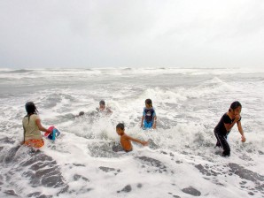
UNFAZED BY ‘CHEDENG’ Children in Aparri, Cagayan, frolic on the seashore unmindful of, even enjoying, the big waves churned by the winds of Typhoon “Chedeng.” RAFFY LERMA
Summer is gone, the wet season is here, and brace yourselves for powerful typhoons—maybe about a dozen more—in the next four months.
Weather forecasters sounded the warning yesterday as Typhoon “Chedeng” headed out of the country, leaving in its wake a stronger southwest monsoon and signaling the end of summer.
Although it veered north on Thursday night and headed toward western Japan, Chedeng still left two people dead and forced some 260,000 others to seek shelter in evacuation centers in the Philippines, officials said.
“The rainy season is here,” chief forecaster Robert Sawi of the Philippine Atmospheric, Geophysical and Astronomical Services Administration (Pagasa) said at a news briefing.
The wet season will last until September, he said.
Returning home last night from an overnight trip to Thailand, President Benigno Aquino III said the government’s preparations for a major typhoon onslaught were not really put to the test but expressed hope the casualties would be limited.
“I hope there will be no more (casualties),” the President said.
Sawi said that with Chedeng moving out of the Philippine area of responsibility, the southwest monsoon would prevail and dump rains over Metro Manila, Southern Luzon, Visayas and Mindanao over the weekend.
He said Pagasa expected more typhoons to enter the Philippine area this year compared to last year.
9-13 cyclones
For the whole of this year, Pagasa expects 18 to 21 tropical cyclones to enter Philippine territory, compared to 11 last year.
The bulk might occur during the next four months, said Fernando Cada, a weather specialist at the climatology division.
Based on forecast models, 9 to 13 cyclones are predicted to enter the country during the June-September period, Cada said.
“They are expected to be strong cyclones,” Cada said.
Graciano Yumul Jr., undersecretary at the Department of Science and Technology, said the country should prepare for strong cyclones. Typhoons as strong as Chedeng will be more frequent, he said.
Southwest monsoon
Pagasa officials said the effects of the southwest monsoon were stronger this year because Chedeng pulled the monsoon inland and strengthened it.
Cada said the monsoon usually only bothered Luzon this time of the year but because of Chedeng, “it reached as far as Visayas and Mindanao and is stronger.”
Chedeng also brought above normal rainfall in the last few days, leading Pagasa to declare that summer had ended.
At least half of the 10 rainfall stations in Luzon and the Visayas must have a total of at least 25 millimeters of rainfall every day for five consecutive days before Pagasa announces the arrival of the rainy season.
Chedeng produced enough rains in the last five days to fill six of the 10 rainfall gauges.
Low pressure area
Pagasa yesterday sighted a low pressure area in the South China Sea, off the coast of western Palawan. This could bring heavy rains over the Mindoro provinces in the next few days, Pagasa officials said.
Cada said the typhoon season is expected to be “strong” this year as the temperature of the Pacific Ocean returns to normal after the La Niña weather phenomenon.
“There are usually more and stronger cyclones during this period,” he said.
Still, although the La Niña is receding, its effects would still be felt in the country for months to come, officials said.
Chedeng gains strength
Chedeng yesterday continued to intensify as it moved away from the Philippines.
As of 4 p.m., it was spotted 160 kilometers east of Basco, Batanes, packing maximum sustained winds of 195 kilometers per hour and gusting at 230 kph. It was forecast to move northwest at 19 kph.
As the typhoon’s outer band touched parts of northern Luzon, Pagasa raised public storm Signal No. 3 over Batanes. Residents there should expect winds of 101-185 kph in the next 18 hours, Pagasa said in its afternoon advisory.
Storm Signal No. 2 was raised over the Babuyan Islands, while Aurora, Cagayan, and Isabela were under Signal No. 1.
Pagasa said Chedeng could exit the Philippines on Saturday evening or Sunday morning.
2 drowned
At least two persons were confirmed dead from drowning in the Bicol region, according to the National Disaster Risk Reduction and Management Council (NDRRMC).
Jaime Torillos, 70, left his home in Gigmoto, Catanduanes, on May 24. He was suffering from Alzheimer’s disease. His body was found at sea the following morning.
Emmanuel Macaro, 27, drowned after falling from a boat on his way back home in Sula, Vinzons, Camarines Norte. He had left the evacuation center to get some clothes.
Thousands evacuate
Despite failing to meet Mr. Aquino’s “zero casualty” order, NDRRMC executive director Benito Ramos said he was still satisfied with the performance of disaster response units.
“We hope they would understand us. We have done our best to coordinate the efforts,” he said, adding the incidents were beyond their control. “We learned a lot from this experience. We will coordinate more with state agencies.”
As of May 27 noon, the NDRRMC reported that 328,963 people, or 67,514 families, were affected by the typhoon in 272 barangays in the regions of Bicol, Zamboanga Peninsula, Davao, Northern Mindanao, the Autonomous Region in Muslim Mindanao and Metro Manila.
Authorities said 262,374 people, or 53,840 families, sought refuge in evacuation centers.
Hundreds of passengers were stranded at airports after nine flights to and from different destinations in Luzon and the Visayas were canceled, airport authorities said.
They included seven Cebu Pacific flights to or from Dumaguete, Caticlan, Isabela and Tuguegarao. A Philippine Air Lines flight from Manila to Dumaguete and back were also canceled. With a report from Tina G. Santos