Hurricane Maria grows on fearsome Irma’s path

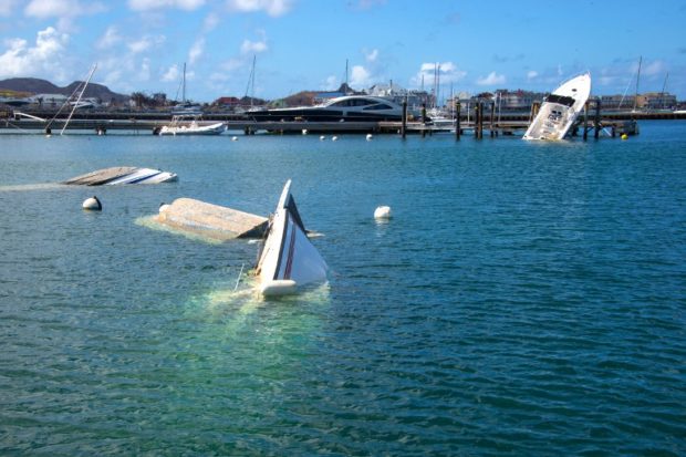
Boats and yatchs are seen sunk and damaged in a harbour on the French Caribbean island of Saint Martin on September 17, 2017, after the island was hit by Hurricane Irma. AFP
Hurricane Maria was forecast Sunday to surge to major hurricane strength as it nears the storm-battered eastern Caribbean with 85 mile (140 kilometer) per hour winds, the US National Hurricane Center said, on a path similar to that of mega storm Irma earlier in the month.
Storm warnings and watches went up in many of the Caribbean islands still reeling from Irma’s destructive passage.
As of 0300 GMT Monday, Maria was a Category One hurricane, the lowest on the five point Saffir-Simpson scale, located 100 miles (165 kilometers) northeast of Barbados while bearing west-northwest at 13 miles (20 kilometers) an hour, the NHC said.
“On the forecast track, the center of Maria will move across the Leeward Islands Monday night and then over the extreme northeastern Caribbean Sea on Tuesday,” it said.
“Rapid strengthening is forecast during the next 48 hours, and Maria is expected to become a major hurricane as it moves through the Leeward Islands,” the NHC warned.
Article continues after this advertisementHurricane warnings were triggered for Guadeloupe, Dominica, St Kitts, Nevis, Montserrat and Martinique.
Article continues after this advertisementLess urgent ‘watches’ were issued for the US and British Virgin Islands where at least nine people were killed during Irma; French-Dutch island St Martin where 15 people died; Saba and St Eustatius; St Barthelemy and Anguilla.
A warning is typically issued 36 hours before the first occurrence of tropical storm-force winds while watches are issued 48 hours in advance.
In the French territory of Guadeloupe, authorities announced a “red alert” from Monday with schools, businesses and government offices ordered closed as officials predicted severe flooding in the lower parts of the island and urged people living there to move to higher ground.
Meanwhile the French island of Martinique was placed on “orange alert” from Monday with high seas and heavy rain expected to cause flooding. Schools and universities will be closed, authorities said.
Tropical storm warnings were in place in Antigua and Barbuda, Saba and St Eustatius, and St Lucia. The tiny island of Barbuda was decimated by Hurricane Irma September 5-6 when it made its first landfall in the Caribbean as a top intensity Category Five storm.
Dangerous storm surges
The NHC said Maria could produce a “dangerous storm surge accompanied by large and destructive waves” that will raise water levels by four to six feet (1.2 to 1.8 meters) when it passes through the Leeward Islands.
It also forecast a maximum potential rainfall of 20 inches (51 centimeters) in the Leeward Islands, Puerto Rico and the US and British Virgin Islands through Wednesday night — conditions that could cause life-threatening flash floods and mudslides.
A second hurricane, Jose, is also currently active in the Atlantic and has triggered tropical storm watches for the northeastern United States.
Irma left around 40 people dead in the Caribbean before churning east and pounding Florida, where at least 20 people were killed.
France, Britain and the Netherlands have been criticized for the pace of relief efforts in their overseas territories amid widespread shortages of food, water and electricity.
Hurricane Irma broke weather records when it sustained winds of 295 kilometers per hour (183 miles per hour) for more than 33 hours.
Many scientists are convinced that mega storms such as Irma are intensified by the greater energy they can draw from oceans that are warming as a result of global climate change.