Tropical Cyclone Warning Signal No. 1 has been raised over the Batanes group of islands as a new storm is forecast to enter the Philippine Area of Responsibility (PAR) on Sunday.
Tropical Storm “Haitang” was last located 385 kilometers west of Basco, Batanes, as of 4 a.m., according to the Philippine Atmospheric, Geophysical and Astronomical Services Administration (Pagasa).
Pagasa said Haitang might enter the PAR “anytime” on Sunday and would be called “Juaning.”
It had maximum winds of 65 kph with gusts of up to 80 kph.
Haitang is expected to skirt the PAR and is forecast to hit Taiwan. It is forecast to exit the PAR sometime on Monday, July 31, 2017.
The 500-km-wide Haitang will affect Batanes within the next 36 hours and bring 30 to 60 kph winds over the island, prompting the cyclone warning signal.
Haitang and Tropical Storm “Gorio,” which exited the PAR at 3 a.m. after lashing Taiwan, are enhancing the southwest monsoon, or habagat, Pagasa said.
The enhanced habagat will affect the Ilocos Regions and the western seaboard, especially Zambales and Bataan. Moderate to heavy rain is expected in these areas, which may experience flooding and landslides, Pagasa warned.
The Cordillera and Central Luzon regions will have cloudy skies with light to moderate rain.
Meanwhile, Metro Manila and the rest of the archipelago will see light to cloudy skies on Sunday. Brief isolated rain and thunderstorms are forecast in these parts of the country. CBB/rga

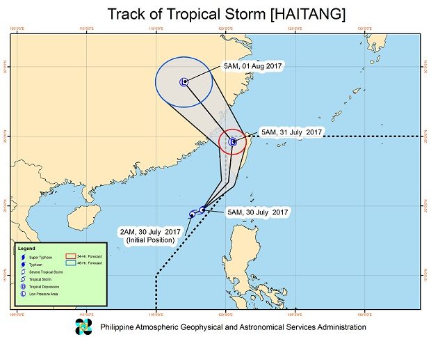
This storm track provided by Pagasa shows Tropical Storm ‘Haitang’ skirting the Philippine Area of Responsibility (PAR) early Sunday, July 30, 2017. Haitang, which will be called ‘Juaning” once it enters the PAR, is seen to hit Taiwan before exiting the PAR on Monday. Pagasa has raised Tropical Cyclone Warning Signal No. 1 over the Batanes due to Haitang. PAGASA IMAGE