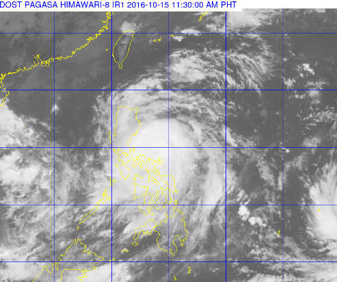
This satellite image from Pagasa shows the current location of Typhoon Karen (international name: Sarika) as of 11:30 a.m. Saturday
The state weather bureau on Saturday placed five areas under tropical cyclone warning signal no. 3 as typhoon “Karen” (international name: Sarika) is on a direct path to hit Luzon.
In its 11 a.m. bulletin, the Philippine Atmospheric Geophysical Astronomical Services Administration (Pagasa) said Karen was spotted 95 kilometers north northeast of Virac, Catanduanes as of 10 a.m. It is expected to make landfall over the Quezon-Aurora area Sunday morning.
Pagasa said the typhoon has a maximum sustained winds of up to 130 kilometers per hour (kph) near the center and gustiness of up to 180 kph.
It, however, is moving faster at 17 kph from 15 kph at 8 a.m. as it heads west northwest.
Public storm signal no. 3 was raised in the provinces of Catanduanes, Camarines Norte, Northern Quezon including Polilio island and Aurora.
Heavy rainfall is being observed in Albay, Catanduanes and Camarines Norte. Camarines Sur, Masbate, Sorsogon, Marinduque, and northern Samar are also experiencing moderate to heavy showers which may last in the next three hours.
Signal no. 2 was raised over rest of Quezon, Camarines Sur, Albay, Rizal, Bulacan, Nueva Ecija, Quirino, Zambales, Tarlac, Pangasinan, Nueva Vizcaya, La Union and Benguet.
Storm surge is possible in coaster areas under Signals No. 2 and 3.
The provinces of Sorsogon, Masbate including Ticao and Burias Island, Isabela, Romblon, Marinduque, Oriental Mindoro, Batangas, Laguna, Cavite, Metro Manila, Pampanga, Bataan, Ifugao and Northern Samar were placed under signal no. 1
Pagasa announced that tropical storm Haima is expected to enter the Philippine Area of Responsibility on Monday. It will be locally named “Lawin.” CDG/IDL