‘Life-threatening’ Hurricane Hermine roars to Florida
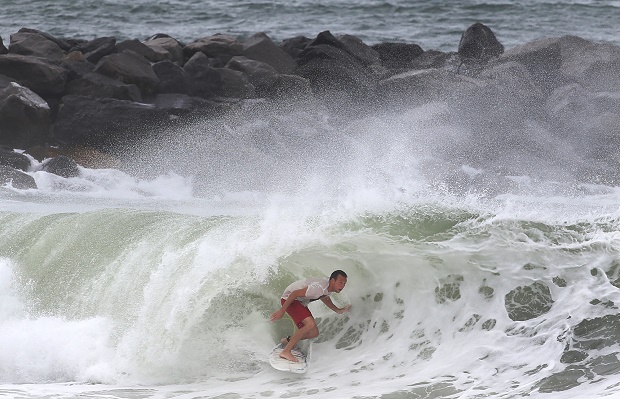
A surfer gets into the tube while surfing the swell from Tropical Storm Hermine at St. Andrews State Park in Panama City Beach, Fla., on Thursday, Sept. 1, 2016. Residents and businesses along Florida’s Gulf coast put up shutters, nailed plywood across storefronts and braced Thursday for Tropical Storm Hermine, a system the governor called potentially “life-threatening” likely to become the first hurricane to strike the state in over a decade. AP
CARRABELLE, Florida — Hurricane Hermine gained strength late Thursday evening as it roared toward Florida’s Gulf Coast, churning up rough surf that battered docks and boathouses as people braced for the first direct hit on the state from a hurricane in over a decade.
The National Hurricane Center said the storm’s top sustained winds rose from 75 mph in the afternoon to 80 mph by nightfall as the former tropical storm gained new fury as it bore down on the coast. Forecasters said the storm would likely gain a little extra punch before slamming ashore.
Hermine’s landfall was expected late Thursday or early Friday in the Big Bend area — the mostly rural and lightly populated corner where the Florida peninsula meets the Panhandle — then drop back down to a tropical storm and push into Georgia, the Carolinas and up the East Coast with the potential for drenching rain and deadly flooding.
Florida Gov. Rick Scott warned of the danger of strong storm surge, high winds, downed trees and power outages, and had urged people during the day to move to inland shelters if necessary and make sure they had enough food, water and medicine.
“This is a life-threatening situation,” Scott said. “It’s going to be a lot of risk. Right now, I want everybody to be safe.”
Article continues after this advertisementCourtney Chason, a longtime resident of Carrabelle in the Big Bend coastal area, warily watched with his girlfriend Thursday evening as surging waves began battering some docks and boathouses, the angry surf slowly tearing at them. Water also crashed into yards closest to the shore.
Article continues after this advertisement“I’ve never seen it this high, it’s pretty damn crazy,” said Chason. “I hope it doesn’t get any higher; we need lots of prayers.”
A strengthened Hermine also sent heavy squalls with its outer bands over Gulf coast beaches elsewhere. By Thursday evening, the normally wide, sugar-sand beach on Treasure Island was entirely covered in water. Palm trees whipped in the wind. Elsewhere along the beach, folks stood gawking at the abnormally large waves and took selfies ahead of the storm.
The city of St. Petersburg was littered with downed palm fronds and tree branches, and low-lying streets were flooded.
In north Florida, some 9,200 power outages also were reported Thursday evening on an outage map maintained by officials in Tallahassee, the capital city located in north Florida about 35 miles from the coast. Utility officials couldn’t immediately be reached for more details though Florida’s governor had warned some of the city’s stately trees might topple over power lines in storm winds.
Scott added that 6,000 National Guardsmen in Florida are ready to mobilize after the storm passes. The governors of Georgia and North Carolina declared states of emergency.
As of 9 p.m. EDT, Hermine was in the Gulf of Mexico, centered about 40 miles (65 kilometers) southeast of Apalachicola, Florida, and was moving north-northeast at about 14 mph (22 kph). Forecasters said it could strengthen slightly before blowing ashore — still as a Category 1 hurricane.
Projected rainfall ranged up to 10 inches in parts of northern Florida and southern Georgia, with 4 to 10 inches possible along the coasts of Georgia and the Carolinas by Sunday. Lesser amounts were forecast farther up the Atlantic Coast, because the storm was expected to veer out to sea.
Florida’s governor ordered many state government offices to close at noon, including those in the Tallahassee, home to tens of thousands of state employees. The city has not had a direct hit from a hurricane in 30 years.
The last hurricane to strike Florida was Wilma, a powerful Category 3 storm that arrived on Oct. 24, 2005. It swept across the Everglades and struck heavily populated south Florida, causing five deaths in the state and an estimated $23 billion in damage.
Residents on some islands and other low-lying, flood-prone areas in Florida were urged to clear out earlier Thursday.
Flooding was expected across a wide swath of the Big Bend, which has a marshy coastline and is made up of mostly rural communities and small towns, where fishing, hunting and camping are mainstays of life.
On Thursday, residents were out in force preparing for the storm, and stores began running low on bottled water and flashlights. City crews struggled to keep up with demand for sand for filling sandbags.
On Cedar Key, a small island along the Big Bend, about a dozen people went from storefront to storefront, putting up shutters and nailing pieces of plywood to protect businesses from the wind.
One of them, Joe Allen, spray-painted on plywood in large black letters: “Bring it on, Hermine.” Despite the bravado, he said, “I’m worried. You can never fully protect yourself from nature.”
Chris Greaves and family members stopped in Tallahassee to pick up sandbags for his garage and the church they attend. Greaves said he lived in South Florida when Hurricane Andrew devastated the area in 1992. While he said he doesn’t expect the same kind of widespread damage, he warned that tropical weather is “nothing to mess with.”/RGA
READ: Florida finds Zika in local mosquitoes, bromeliads blamed