Butchoy intensifies; to boost habagat in south Luzon, Visayas

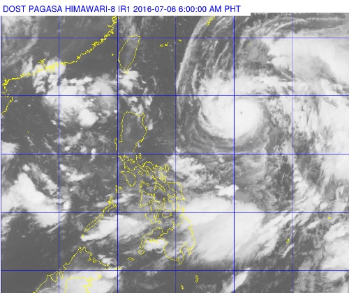
The satellite photo from Pagasa shows Typhoon ‘Butchoy’ swirling at the right of Luzon. Habagat clouds can be seen clustered over parts of the Visayas and much of Mindanao. PAGASA PHOTO
Updated July 6, 2016, 9:10 a.m.
Typhoon Butchoy (international name: Nepartak) gained strength early Wednesday as it continued its northwest track.
The typhoon packed maximum sustained winds of 185 kilometers per hour near the center and gusts of up to 220 kph, the Philippine Atmospheric Geophysical and Astronomical Services Administration (Pagasa) said at 5 a.m.
READ: Typhoon ‘Butchoy’ enters PAR
Butchoy was last tracked 1,010 kilometers east of Aparri, Cagayan and maintained its speed of 30 kph northwest.
Article continues after this advertisementPagasa noted that while “Butchoy” has intensified, it maintains its speed and direction.
Article continues after this advertisementAs of 7 a.m., the typhoon eye was located at 930 km east of Aparri, Cagayan. It is forecast to continue moving northwest at 30 kph, and is expected to be 650 kilometers east of Basco, Batanes by this evening.
Forecasters earlier said that the typhoon won’t make landfall but would enhance the southwest monsoon prevailing over Southern Luzon and the Visayas.
Yesterday, National Disaster Risk Reduction and Management Council (NDRRMC) executive director Ricardo Jalad said the heaviest rainfall is expected from Thursday to Saturday.
For today, cloudy skies with light to moderate rain and thunderstorms will be experienced over Metro Manila, Central Luzon, CALABARZON, MIMAROPA, the Bicol region, the Visayas, Northern Mindanao, Caraga and Davao, Pagasa said.
Moderate to strong winds blowing from the southwest are also expected over southern Luzon, Visayas, Mindanao and the eastern section of northern and Central Luzon. The coastal waters along these areas will be moderate to rough, Pagasa said.
Partly cloudy to cloudy skies with isolated rainshowers or thunderstorms will prevail over the rest of the country.
Pagasa weather division chief Esperanza Cayanan also reported to the NDRRMC yesterday that “Butchoy” was forecast to exit the Philippines on July 8. /CDG