‘Ineng’ threatens N. Luzon
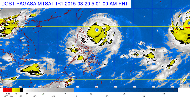
Pagasa satellite image as of 5:00 AM, Thursday, August 20, 2015
Typhoon “Ineng” (international name: Goni) brought stormy weather over northern Luzon, just two weeks after it was battered by another powerful typhoon, “Hanna” (Soudelor).
Ineng packed maximum winds of 180 kilometers per hour and gusts up to 215 kph as the typhoon’s center moved eastward toward extreme northern Luzon at 23 kph.
With the eye of the typhoon about 690 km east of Calayan, Cagayan, the state weather bureau on Wednesday raised public storm warning signal No. 2 over Cagayan and Batanes provinces and adjacent islands, warning of stormy winds from 61 to 120 kph in the next 24 hours.
Public storm warning signal No. 1 was raised over Isabela, Kalinga, Apayao, Abra and Ilocos Norte, which would experience stormy winds from 30 to 60 kph in the next 36 hours.
The latest track forecast from the Philippine Atmospheric Geophysical Astronomical Services Administration (Pagasa) said the typhoon’s eye would come closest to land at about 120 km east southeast of Batanes on Friday morning.
From that distance, Ineng will still batter the country’s northernmost islands due to its 700 km diameter.
The forecast showed typhoon will slowly recurve toward Japan and exit from the Philippine area of responsibility on Monday.
Pagasa, meanwhile, warned against sea travel over the eastern seaboard of Luzon due to the typhoon.–Dona Z. Pazzibugan