354-kph Supertyphoon ‘Hanna’ to enter PH
What has developed into the world’s strongest typhoon so far this year will enter the Philippine area of responsibility (PAR) on Wednesday morning but will spare the country from landfall.
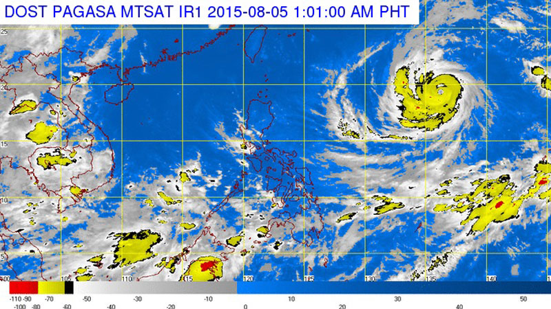
The weather bureau placed the maximum sustained winds of Supertyphoon “Hanna” (international name: Soudelor) at least 220 kilometers per hour, but the US Joint Typhoon Warning Center (JTWC) in Honolulu said the storm was packing gusts up to 354 kph.
The Philippine Atmospheric, Geophysical and Astronomical Services Administration (Pagasa) said Hanna, the eighth cyclone to visit the country this year, would trigger heavy monsoon rains over most of Luzon and the Visayas over the weekend.
As of Tuesday, the cyclone already bore maximum sustained winds of 215 kph and gusts up to 250 kph and will likely intensify further as it barrels across the Pacific Ocean.
“It will possibly be a supertyphoon when it enters the Philippine area of responsibility on Wednesday morning. This is the strongest [typhoon] this year,” said state meteorologist Buddy Javier.
Article continues after this advertisementPagasa categorizes as supertyphoons those that reach maximum sustained winds of at least 220 kph.
Article continues after this advertisementThe storm was roaring across the western Pacific Ocean packing wind gusts up to 354 kph, according to the JTWC, which rated it a maximum Category 5.
The typhoon was expected to be down to Category 4 or 3 by the time it hit southern Japan, Taiwan and China from late Thursday.
As of Tuesday night, the supertyphoon’s center was spotted 1,700 km east of Luzon. Moving west northwest at 20 kph toward northern Luzon, it is expected to enter the PAR Wednesday morning.
Damage extensive
No deaths have been attributed to Soudelor, but it left a trail of destruction across the Northern Marianas where acting Gov. Ralph Torres declared a “state of major disaster and significant emergency” after it struck late Sunday.
Nearly 400 people were packed in emergency shelters after Soudelor ripped roofs off houses and left residents without power, water and wastewater services.
“I’ve seen multiple primary power poles down; I’ve seen cars flipped over the road; I’ve seen lots of torn roofs,” John Hirsh, executive director of the American Red Cross in Saipan, told Pacific Daily News.
Damage was “extensive” across the island and there had been significant damage to public infrastructure, he said.
Many roads were impassable in Saipan—the Northern Marianas’ main island, the seat of government and hub of the local economy—while in the harbor at least three vessels were ripped from their moorings.
Enhanced monsoon
“It will not make landfall but it will enhance the southwest monsoon over a wide area of Luzon and the Visayas from Friday to Saturday,” Javier said.
For the rest of the week, the supertyphoon will move closer to northern Luzon though it will remain several hundred kilometers from Batanes before it exits the PAR on Saturday morning if it maintains its present speed and track.
From the Philippines, the supertyphoon is headed toward Taiwan.
As of Tuesday night Pagasa had not raised any gale warning or storm warning signals due to the incoming supertyphoon.
Even before the supertyphoon could hit the country, Pagasa warned Tuesday that monsoon rains might trigger flash floods and landslides over Mindanao.
Flooding in Maguindanao
A gale warning was also raised over the seaboards of Mindanao due to the southwest monsoon.
The Visayas and Mindanao as well as Palawan province have been experiencing monsoon rains for the past few days.
In Maguindanao province, at least 30 villages in four towns have been submerged by flood water spawned by a intertropical convergence zone (ITCZ), disaster officials said.
Myrna Angot, chair of the Office of Civil Defense in the Autonomous Region in Muslim Mindanao (ARMM), said the affected villages were low-lying communities near the Liguasan marsh.
These are the towns of Datu Montawal, Pagalungan, Sultan sa Barongis and Paglat.
“No evacuation or displacement yet,” Angot said. “If the rain continues, chances are people will vacate their homes to higher grounds.”
Maguindanao, North Cotabato and Sultan Kudarat provinces have been experiencing light-to-moderate rain the past three days brought about by the ITCZ.
HEART
Angot said the Humanitarian Emergency Response and Action Team (HEART), the disaster action team of the ARMM, was preparing to extend aid to affected families.
Water in some villages of Montawal and Sultan sa Barongis has risen to knee level and residents fear the bad weather will worsen the situation.–With reports from Edwin O. Fernandez, Inquirer Mindanao; and AFP
RELATED STORIES
Super Typhoon Soudelor to spare PH but will enhance ‘habagat’