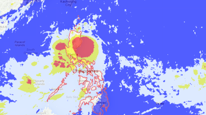
‘Egay’ makes landfall over Palanan in Isabela
Tropical Storm “Egay” has made a landfall over Palanan, Isabela, the state weather bureau said Saturday night in its 11 p.m. bulletin.
The Philippine Atmospheric, Geophysical and Astronomical Services Administration (Pagasa) said Egay was moving west northwest at a faster speed of 11 kilometers per hour from the previous 9 kph. It was last spotted in the vicinity of Palanan, Isabela, as of 10 p.m.
It continued to pack maximum sustained winds of 95 kph and gustiness of up to 120 kph.
Egay is forecast to be 115 kilometers north of Aparri, Cagayan, by Sunday afternoon, 60 km north of Basco, Batanes, by Monday afternoon and 400 km north northeast of Basco by Tuesday afternoon.
It will finally be outside of the Philippine area of responsibility (PAR) by Wednesday afternoon, Pagasa said.
Public storm warning signal No. 2 remained hoisted over Kalinga, Apayao, Isabela, Quirino, northern Aurora, Cagayan, including the Babuyan and Calayan Group of Islands.
The rest of Aurora, Nueva Ecija, Nueva Vizcaya, Ifugao, Benguet, Mt. Province, Ilocos Sur, Abra and Ilocos Norte remained under signal No. 1 with Batanes being added in the 11 p.m. weather bulletin.
Metro Manila and other parts of the country will experience rain and thunderstorms as Egay will continue to enhance the southwest monsoon, Aurelio said in a press briefing.
“Due to the southwest monsoon enhanced by Tropical Storm Egay, Metro Manila, Bicol, Calabarzon and Mimaropa will have cloudy skies with moderate to occasional heavy rains which may trigger flash floods and landslides,” Aurelio said.
Meanwhile, another tropical storm is expected to enter the PAR on Wednesday or Thursday.
Tropical Storm “Chan-Hom,” which will be named “Falcon,” will enter through the upper-right corner of the PAR, Aurelio said.
But it will not “make landfall and no area will be affected because it is far,” he said.
Meanwhile, six Cebu Pacific flights were canceled on Saturday due to inclement weather.
In an advisory, the Manila International Airport Authority said the Manila to Busuanga and Manila to Tuguegarao flights and back were canceled “due to the monsoon rains brought by Tropical Storm Egay.”
The flights canceled were 5J 529, 5J 530, 5J 504, 5J 505, 5J 506 and 5J 507.
Cebu Pacific said it had “arranged additional flights to reaccommodate the affected passengers.”–Rick Alberto and Rima Granali with Kristine Felisse Mangunay
RELATED STORIES
‘Egay’ slows down but intensifies; signal No. 2 up in 8 areas
‘Egay’ picks up speed; NCR, 3 other regions to get heavy rains
