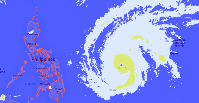
PH braces for ‘Maysak’
IT’S summer, but oddly many Filipinos would find themselves bracing for another potentially destructive typhoon in the next few days.
Typhoon “Maysak,” which will be locally named “Chedeng” when it enters the Philippine area of responsibility by Wednesday evening or early Thursday, packed maximum sustained winds of 195 kilometers per hour and gusts of up to 230 kph, according to the late afternoon bulletin of the Philippine Atmospheric, Geophysical and Astronomical Services Administration (Pagasa) Wednesday.
It was moving at 17 kph west-northwest, the state weather bureau said Wednesday afternoon.
The typhoon was last plotted at 1,165 kilometers east of Guiuan, Eastern Samar. It had a diameter between 600 and 700 kilometers.
Maysak is expected to make landfall on late Saturday or early Sunday on the eastern part of Central/northern Luzon.
Article continues after this advertisementThe typhoon will affect the country during the Holy Week, when Filipino Catholics deeply practice their faith. Also for many, it is time for a long vacation.
Article continues after this advertisementEsperanza Cayanan, officer in charge of Pagasa, said the typhoon still has a chance to recurve but most warning centers show that it would slam Central Luzon.
Good weather is expected until Friday but eastern Luzon may experience some rains and gusty winds.
Storm signals may also be raised over Bicol and Samar provinces within 24 hours.
Rene Paciente of Pagasa said that Maysak might bring a storm surge of four to five meters or one and a half-story building.
Government preparations
Interior Undersecretary Austere Panadero said the local government must inform their residents on weather updates as the typhoon draws near.
Military units in Luzon and Visayas were also placed on red alert ahead of the typhoon.
NDRRMC Executive Director Alexander Pama asked the public to cooperate to achieve zero casualty.
“Alam natin lahat karamihan sa atin ngayon ay holiday mode. Lahat ng sector walang pasok ang opisina at paaralan sa punto pong yan pinakikiusap natin sa kababayan ang formula para magtagumpay ang zero casualty ang kahandaan ng gobyerno at kooperasyon ng mamamayan,” he said.
NDRRMC Chairman Voltaire Gazmin, meanwhile, did not directly advise the public to cancel their plans for the Holy Week but they should make adjustments when necessary.
“Di naman sinasabi na i-cancel nila but they should make necessary adjustments. Mararamdaman natin yung bagyo Friday evening or Saturday, ito yung pagbalik nila, and they should make necessary adjustments,” he said.
He also urged the public to continuously monitor weather forecasts.
Cancellation of flights and sea travel will still depend on the weather updates.
“We have to monitor weather updates. From there, the Coast Guard will advise whether vessels will be allowed. With regard to canceled flights or possible delays, it will be coordinated by airport authorities,” Cecille Natividad, Director for Operations of the Department of Transportation of Communications said. AC
