‘Hazards risk’ list baffles Lucena
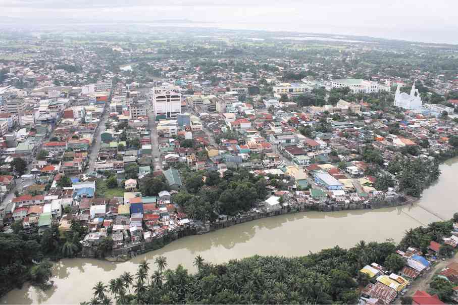
LUCENA’S center is wedged between the Dumacaa River (foreground) on the east and the Iyam River on the west. DELFIN T. MALLARI JR.
LUCENA CITY—Mayor Roderick Alcala could not believe it: Lucena is third among 100 cities in the world that are most prone to natural disasters, according to a United Kingdom-based risk analysis organization.
“I’m now 40 years old and not once did I witness a single natural disaster of alarming magnitude in this city,” Alcala said in an interview on Tuesday. The mayor, who belongs to a local political clan, was born and raised in Lucena, the capital of Quezon province.
He said the findings of Verisk Maplecroft were not supported by facts on how and why Lucena was on its list and that the company should correct its study as it might affect not only the peaceful lives of its citizens but also the entry of investors to Lucena.
Verisk Maplecroft describes itself on its website as “a leading global risk analytics, research and strategic forecasting company offering an unparalleled portfolio of risk solutions.” On March 4, it released its fifth annual Natural Hazards Risk Atlas and identified the 100 cities in the world which, it said, were most prone to natural disasters.
“Natural hazards constitute one of the most severe disrupters of business and supply chain continuity, and also threaten economic output and growth in some of the world’s key cities, especially for those located in the emerging markets,” it said.
The company listed Port Vila, the capital of Vanuatu in the South Pacific, as the most vulnerable to natural hazards, followed by Tuguegarao City in Cagayan province and Lucena, both in the Philippines. Manila was the fourth most exposed city to natural hazard in the world, followed by San Fernando (province undisclosed), fifth; and Cabanatuan City, sixth.
Tuguegarao, Lucena and Manila were rated “highly prone to earthquakes and typhoons,” along with Kawasaki (15th), Osaka (16th) and Nara (17th) in Japan.
The analysis considers the combined risk posed by tropical storms and cyclones, floods, earthquakes, tsunamis, severe storms, extratropical cyclones, wildfires, storm surges, volcanoes and landslides.
Based on data from the Lucena City Disaster Risk Reduction Management Council, the natural disaster that could hit the city is flash flooding from its two major rivers.
Lucena’s center is wedged between the Dumacaa River on the east and the Iyam River on the west. The waterways meet on the southern portion of the city and flow to the Tayabas Bay.
Citing historical record, Alcala said the only time the two rivers overflowed, forcing some residents to evacuate, was in 1995 when Typhoon “Rosing” struck.
The rivers would often swell when accumulated rainwater atop Mt. Banahaw converges with the surge of seawater from the Tayabas Bay brought by rising tide.
Perla Manzano, a laundrywoman who lives along the bank of the Iyam noted “occasional floods when the river swells. But we’re already used to it. We just evacuate to safe grounds,” she said.
A few years ago, the Department of Environment and Natural Resources and the University of the Philippines’ National Institute of Geological Sciences released results of a study, which showed low-lying areas of Lucena in constant danger from flood unless the two rivers were cleared of garbage and natural debris from Banahaw.
“There might have been a misunderstanding on the identification of the exact location on what particular part of Quezon is really in danger to any form of disasters,” Alcala said. He said Verisk Maplecroft should categorically identify which part of the province was in real danger or exposed to catastrophic disasters.
According to the mayor, the city government has been strengthening its capabilities for a disaster of that nature.
He said his administration had initiated the Lucena Twin Rivers Development Program to undertake massive cleanup and dredging activities in the shallow areas.
The program also aims to convert the Iyam and Dumacaa into a tourist attraction by putting up “floating restaurants” on certain portions of the waterways.
Last year, the city government initiated the mass planting of thousands of mangrove propagules along the riverbanks.