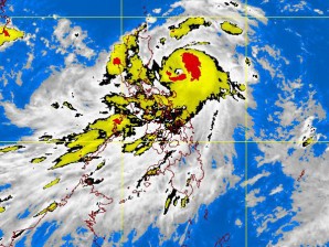
MANILA,Philippines – Signal No. 3 has been raised over several provinces in Eastern Luzon and signal 2 over Metro Manila as typhoon “Pedring” (international name: Nesat) intensified further, the state weather bureau said Monday.
In its latest weather bulletin, the Philippine Atmospheric, Geophysical and Astronomical Services Administration (Pagasa) said that Pedring was seen 260 km east southeast of Casiguran, Aurora as of 4 pm. Pedring was packing maximum sustained winds of 130 kph near the center and gusts of up to 160 kph, Pagasa said.
Pedring was forecast to move west northwest at 19 kph.
Signal number 3 was raised over Catanduanes, Camarines Sur, Camarines Norte, Northern Quezon, Polillo Island, Aurora, Quirino and Isabela.
Meanwhile, signal number 2 has been raised over Metro Manila and the provinces of Albay, Burias Island, Sorsogon, the rest of Quezon, Rizal, Bulacan, Nueva Ecija, Nueva Vizcaya, Ifugao, Benguet, Mt. Province, Kalinga and Cagayan.
Meanwhile, signal number 1 has been raised over Ticao Island, Masbate, Marinduque, Batangas, Cavite, Bataan, Pampanga, Zambales, Tarlac, Pangasinan, La Union, Ilocos Sur, Ilocos Norte, Abra, Apayao, Northern Samar, Calayan and Babuyan Group of Islands.
Residents living in low lying and mountainous areas where storm signals have been raised were warned against possible flashfloods and landslides. Likewise, those living along coastal areas were alerted against storm surges caused by the typhoon.
Pagasa said that estimated rainfall amount is between 15 to 25 mm per hour within the 650 km diameter of Pedring.
Pedring is also expected to enhance the southwest monsoon and will bring scattered to widespread rains over Southern Luzon and Visayas, the state-run weather bureau said.
Strong rains and winds were expected to be felt throughout Luzon from Monday night up to Tuesday morning.
Pagasa administrator, Nathaniel Servando, said that Pedring was still at sea and continues to intensify but it is not likely to reach Signal no. 4.
Robert Sawi, Pagasa’s chief weather forecaster, has alerted the public to possible, landslides, flash floods, strong winds, storm surges and tornadoes.
Sawi said that Pedring is expected to exit the country through the Ilocos region Wednesday night.
Pedring was forecast to make landfall over Casiguran, Aurora early Tuesday and will be in the vicinity of Baguio City by Tuesday afternoon.
By Wednesday afternoon, Pedring was expected to be 410 km west northwest of Sinait, Ilocos Sur and by Thursday afternoon, the typhoon was forecast to be 820 km west northwest of Sinait, Ilocos Sur, Pagasa said.
Binga dam and Magat dam were said to have opened their gates and released water as early as Sunday in anticipation of the rains brought by Pedring. They are 0.18 and 1.71 meters, below spilling level, respectively, as of 10AM Monday, Pagasa said.
