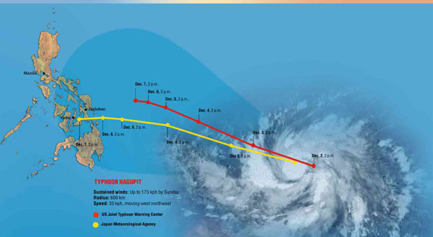
MANILA, Philippines—Typhoon “Hagupit” will have a 60 percent chance of making landfall in Eastern Visayas on Saturday afternoon or evening, the state weather bureau said.
Aldczar Aurelio, forecaster of the Philippine Atmospheric Geophysical and Astronomical Services Administration (Pagasa), said in a televised press conference on Wednesday that Hagupit will enter the Philippine area of responsibility (PAR) Thursday morning.
Once it enters PAR, Hagupit will be named locally as “Ruby.”
Pagasa did not rule out the possibility that Hagupit will veer off toward Japan.
Aurelio assured the public that Ruby will not be as strong as “Yolanda.”
“Malakas pa rin ang hangin pero hindi sinlakas ng Yolanda,” Aurelio said.
Whether Hagupit will make landfall or not, the state weather agency said the typhoon will dump moderate to heavy rains which will lead to possible flash floods in low-lying areas and landslides in mountainous areas.
According to Pagasa’s latest weather bulletin issued at 11 a.m., the typhoon was seen 1,610 kilometers east of Davao City, packing maximum sustained winds of 140 kilometers per hour (kph) near its center and gustiness at 170 kph.
Hagupit is moving west northwest at 30 kph.
RELATED STORIES
‘Yolanda’-like ‘Ruby’ heads for PH
‘Hagupit’ may intensify into typhoon