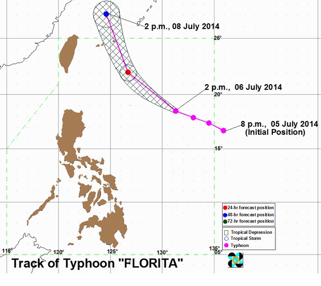
MANILA, Philippines – Typhoon “Florita” (international name: Neoguri) intensified as it entered the Philippine area of responsibility early Sunday, although it is not expected to make landfall.
Packing maximum sustained winds of 175 kilometers per hour and gustiness of up to 120 kph, the eye of the typhoon was located 890 kilometers east of Aparri, Cagayan on Sunday afternoon and moving in a west northwest direction.
The weather bureau Pagasa (Philippine Atmospheric Geophysical and Astronomical Services Administration) did not raise public storm signals.
But it said the typhoon enhanced the southwest monsoon and will bring moderate rains and thunderstorm over the Bicol and Mimaropa regions and the Visayas.
The rest of Luzon will experience occasional rains, Pagasa said.
The typhoon is also expected to bring about rough sea conditions, and fishing boats and other small sea craft were told not to venture out in the eastern seaboard of Luzon and Visayas.
Pagasa issued a gale warning on Sunday, saying strong to gale force wind is expected to affect the eastern seaboard of Southern Luzon and the Visayas.
By Monday morning, Pagasa forecast the eye of the typhoon to be 530 kilometers east of Basco, Batanes.
Since it is expected to maintain its west northwest path, Typhoon Florita is forecast to be out of the Philippine area of responsibility by Tuesday morning heading toward Taiwan, according to the weather bureau.
Typhoon Florita is the sixth tropical cyclone to affect the country this year.
RELATED STORIES
