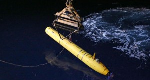
This handout photo taken on April 18, 2014 and received on April 20, 2014 from the Australian Defense Department shows the Phoenix International Autonomous Underwater Vehicle (AUV) Artemis (C) being moved by crane over the side of Australian Defense vessel “Ocean Shield” in the search for missing Malaysia Airlines flight MH 370 in the Indian Ocean. AFP FILE PHOTO / AUSTRALIAN DEFENSE/LSIS BRADLEY DARVILL
CANBERRA, Australia – A Chinese navy survey ship is scheduled to start mapping the seabed off the west Australian coast this week as part of the latest phase in the search for the Malaysian airliner.
Australia’s search coordination center says Chinese, Australian and Malaysian authorities met at the west coast port of Fremantle at the weekend and agreed that the Chinese ship will conduct a bathymetric survey of the Indian Ocean floor.
The center said Monday the ship is scheduled to sail for the survey area on Wednesday.
Officials believe the Malaysia Airlines Boeing 777 that vanished with 239 passengers and crew on March 8 during a flight from Kuala Lumpur to Beijing veered far off course and crashed in the southern Indian Ocean.