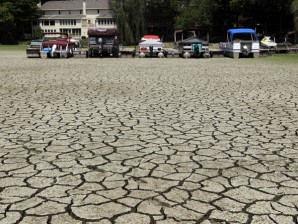
MANILA, Philippines—The state weather bureau warned not only of drier conditions and decreased rainfall but also of stronger storms as El Nino is likely to make its presence felt in June.
“A majority of climate models indicate that El Niño may develop this year. El Niño is characterized by unusually warm ocean surface temperatures in the central and eastern equatorial Pacific (CEEP),” the Philippine Atmospheric Geophysical and Astronomical Services Administration said in a statement on Thursday.
“Pagasa has already noted significant increase in the [sea surface temperature] from 0.2 to 0.4 C from April 21 to April 28, 2014. Because of this development and as climate models predict that this condition may persist for the next nine months,” Pagasa said.
Pagasa is foreseeing the onset of El Niño in June which may peak during the last quarter of 2014 and may last up to the first quarter of 2015.
The onset of southwest monsoon or (habagat), which is the rainy season in the Philippines, is usually in the month of June. It often lasts up to November. “El Niño could affect the normal rainfall pattern in the country generally resulting in reduced rainfall. Different parts of the country may experience varying rainfall impacts,” Pagasa said, adding that it will release a monthly rainfall outlook for six months for the different parts of the country.
Pagasa said that the country could still experience normal number of tropical cyclone this year. The Philippines is battered with an average of 20 cyclones per year.
“However, El Niño causes the behavior of tropical cyclones to become erratic, affecting its tracks and intensity. The tropical cyclone tracks are expected to shift northward and its intensity could become stronger,” Pagasa said.
RELATED STORIES
El Niño, La Niña unlikely to make an appearance in 2013—WMO


