Island-hopping ‘Yolanda’ to be felt in Metro Manila
MANILA, Philippines—Supertyphoon “Yolanda” (international name Haiyan) will be felt in Metro Manila late Friday afternoon as one of the most powerful storms ever recorded goes “island hopping,” the state weather bureau said.
“It will be felt in Metro Manila at about 5 to 6 p.m. as Yolanda approaches San Jose in Mindoro,” Vicente Malano, officer in charge of the Philippine Atmospheric Geophysical and Astronomical Services Administration, said.
It will be the nearest Yolanda could get to the Philippine capital. Heavy to intense rains are expected in Metro Manila.
It will then head towards Busuanga in Palawan before it exits the Philippine landmass in the evening.
Before it proceeds to Mindoro, Yolanda is forecast to go “island hopping” in Malay, Aklan where the world-famous Boracay island is located, Malano said. It will go next to Semirara Island in Antique.
Article continues after this advertisementYolanda is expected to exit the Philippine area of responsibility on Saturday morning.
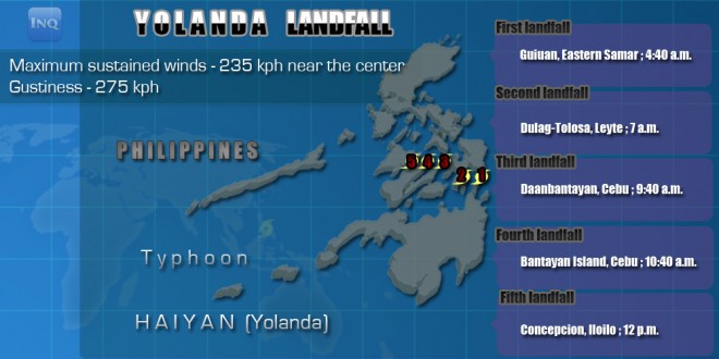
Article continues after this advertisementThe typhoon was last observed offshore of Tibiao, Antique at 2 p.m. It made five landfalls in the Visayas since early Friday.
As of 5 p.m., storm signal was downgraded from Signal No. 2 to Signal No. 1 in Metro Manila.
RELATED STORIES
Strongest typhoon makes fifth landfall
Close to 3,000 passengers stranded in various ports—PCG
