More areas placed under storm signal No. 4 due to ‘Yolanda’
MANILA, Philippines — The Philippine Atmospheric, Geophysical and Astronomical Services Administration (PAGASA) raised storm warning signals in more areas, including Metro Manila, as of 8 p.m. Thursday, after typhoon Yolanda (international name Haiyan) gained speed and strength as it approached the Eastern Visayas.
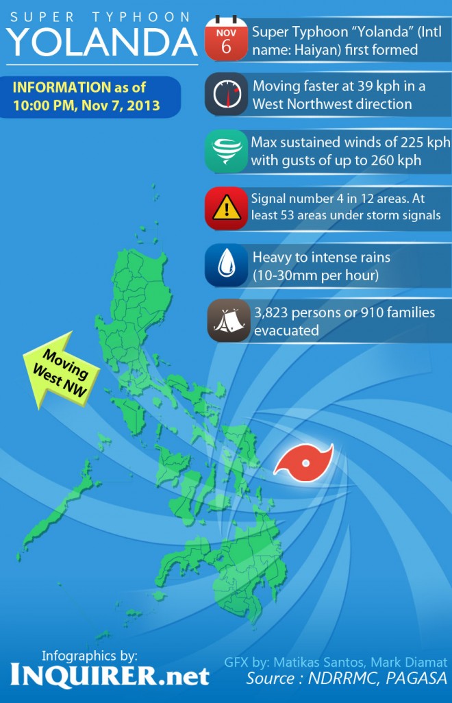
From maximum sustained winds of 215 kilometers per hour, Yolanda intensified with maximum sustained winds of 225 kilometers per hour near the center and gustiness of up to 260 kilometers per hour at 8 p.m. The state weather bureau said it was moving west-northwest at 39 kilometers per hour.
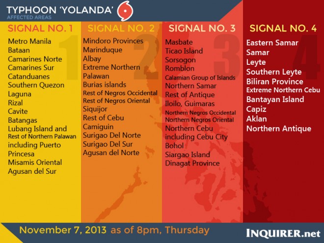
PAGASA hoisted the public storm warning signal 4 over Eastern Samar, Samar, Leyte, Southern Leyte, Biliran province, extreme northern Cebu, Bantayan island, Capiz, Aklan, and northern Antique.
Storm warning signal 3 is up over Masbate, Ticao Island, Sorsogon, Romblon, and the Calamian Group of Islands in Luzon; Northern Samar, the rest of Antique, Iloilo, Guimaras, northern Negros Occidental, northern Negros Oriental, northern Cebu including Cebu City, Bohol, and Northern Samar in the Visayas; as well as Siargao Island and Dinagat Province.
Signal number 2 was raised over Mindoro Provinces, Marinduque, Albay, extreme northern Palawan, and Burias island in Luzon; rest of Negros Occidental, rest of Negros Oriental, Siquijor, and the rest of Cebu in the Visayas; as well as Camiguin, Surigao Del Norte, Surigao Del Sur, Agusan Del Norte.
Storm warning signal 1 is up over Metro Manila, Camarines Norte, Camarines Sur, Catanduanes, southern Quezon Laguna, Rizal, Cavite, Batangas, Lubang Island, the rest of Northern Palawan including Puerto Princesa, Misamis Oriental and Agusan del Sur.
‘Yolanda’ to hit land Friday morning in Eastern Visayas; Signal no. 4 up in 5 provinces
… Signal no. 3 hoisted over 7 provinces, areas; signal no 2 raised over 18 areas; signal 1 over 11 areas
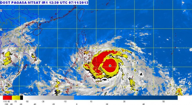
Yolanda, described by forecasters to be almost the size of the Visayas, is expected to make landfall Friday morning in the Eastern Visayas.
Forecasters from the Philippine Atmospheric, Geophysical and Astronomical Services Administration (PAGASA) forecasters said that Metro Manila would start feeling the effects of the 600 kilometer-diameter typhoon, light to moderate rains and gusty winds, by Friday evening.
PAGASA officials also warned of storm surges caused by the typhoon, which could generate waves with heights of up to 7 meters in coastal waters along Yolanda’s path.
In areas where signal 4 has been raised, PAGASA’s senior forecaster Jori Loiz said that the damage to the affected communities could be quite heavy and all travel and outdoor activities should be cancelled. “Evacuation to much safer shelters should have been completed earlier since it may be too late under this situation,” it added.
Loiz said winds of 101 kilometers per hour to 185 kilometers per hour should be expected in at least 18 hours in areas where signal no. 3 has been raised.
Winds of 61 kilometers per hour to 100 kilometers per hour are to be expected in at least 24 hours in areas under signal no. 2, according to Loiz.
Winds of 30 kilometers per hour to 60 kilometers per hour should be expected in at least 36 hours in areas covered by signal no. 1, Loiz said.
The typhoon would cross the provinces of Leyte, Biliran, the northern tip of Cebu, Iloilo, Capiz, Aklan, Romblon, Semirara Island, the southern part of Mindoro and Busuanga after making landfall, the forecaster said. It is expected to leave the landmass on early morning Saturday towards the west Philippine Sea.
According to the weather forecaster, the estimated amount of rainfall is from 30 mm per hour to 50 mm per hour in areas on the massive typhoon’s path. “That is beyond torrential levels,” he told the Philippine Daily Inquirer, adding that the typhoon has been moving very fast but has not changed track since its approach to the Philippine area of responsibility.
“It will be both strong winds and torrential rains in areas of Southern Luzon, the Visayas and Mindanao. But in Metro Manila, the typhoon’s outer cloud bands would bring light to moderate rains and gusty winds,” Loiz said.
Forecasters said that in Metro Manila, storm signal warning 1 or 2 might be raised by Saturday morning.
RELATED STORIES:
More areas placed under storm signal No. 4 due to ‘Yolanda’


