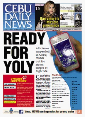
“It’s better to be ready. We are very concerned about the safety of our children. We won’t compromise that,” said Gov. Hilario Davide III as preparations were underway in various cities and towns.
Heavy rains will be experienced today. The typhoon, packing 215-kilometer winds, is expected to make land fall over Samar-Leyte noontime Friday between 11 a.m. to 1 p.m., and exit on Sunday morning, said Oscar Tabada, OIC of the Pagasa Visayas office.
Government workers in the Capitol and Cebu City Hall will still report for work today.
Private employers were asked to give their staff time off to prepare their households for the storm, but the decision of whether to suspend work or declare half-day work today is left to them.
“We encourage private companies to be lenient with their employees. They shouldn’t be strict if there will be absences or under time,” Cebu City Mayor Michael Rama said.
STORM SURGES
Coastal residents were warned of possible storm surges at high tide in the pre-dawn hours.
High tide is expected at 1.9 meters after midnight at 12:25 a.m. Thursday, at 1:09 a.m. on Friday, and 1:47 a.m. on Saturday Nov. 9.
“We expect the typhoon to hit the northern part of Cebu but because of its big diameter, we are focusing attention on the whole province, said Neil Sanchez, head of the Cebu province disaster office.
BIG ONE
In Manila, Pagasa Weather forecasting section chief Rene Paciente said the storm would be “a big one” and was steadily approaching central Philippines.
He said he expected the storm (international name Haiyan) to reach at least 215 kph in strength “conservatively,” and even up to 250 kph.
Paciente said the island provinces that would most likely be heavily hit, include Samar and Leyte, Masbate, Romblon, Northern Cebu, Northern Panay, Mindoro and northern Palawan.
But he did not discount the possibility that the typhoon could track northwest-ward, in which case it would affect Southern Luzon, and even Metro Manila.
Paciente said the weather disturbance, having a diameter of 600 kilometers, would spawn strong winds, and heavy rains originating from the “wall” of the typhoon’s eye.
By Thursday evening, he said he expected Signal No. 4, the highest storm alert, to be hoisted over the Visayas.
Gradually improving weather will be seen over the Visayas by Saturday afternoon.
He said Haiyan would also bring substantial rainfall. Expect moderate to heavy rains falling at 7.5 to 20 millimeters per hour over the areas directly hit by the typhoon, he said.
This means that a square meter container will have collected 7.5-20 liters of water after an hour of rain. (A millimeter of water equals a liter of water on a square meter.)
Due to its relatively fast movement, there’s a chance Haiyan may not be as destructive as some recent storms, unless it hits heavily populated areas, according to Paciente.
He noted that the storms with the highest recorded wind speeds were not necessarily the most destructive or the most deadly.
Rapidly intensifying over the Pacific Ocean, “Haiyan” has turned into a “supertyphoon,” which is predicted to strike at noon Friday.
The Hawaii-based Joint Typhoon Warning Center (JTWC) said the typhoon quickly strengthened over the past 24 hours from 65 knots (120 kilometers per hour) to the current intensity of 130 knots (241 kph), which qualified Haiyan as a supertyphoon under US meteorological standards.
Pagasa does not officially use supertyphoon as a classification. It calculates wind speeds based on 10-minute averages, unlike the JWTC’s minute-long measurements, resulting in lower estimates.
Haiyan is the 24th tropical cyclone to arrive in the country.
Upon making landfall, the typhoon “will weaken as it tracks across the Philippine islands, but should emerge over the South China Sea near a 110 knot intensity (203.72 kph),” said the JTWC.
Potential destructive effects of a Signal No. 4 typhoon (more than 185 kph winds) include coconut plantations suffering extensive damage, many large trees uprooted, power and communication services severely disrupted, and very heavy damage to communities.
POLICE BOATS
The regional police checked their rescue equipment on orders of Chief Supt. Danilo Constantino.
He said the headquarters in Camp Sergio Osmena has two rubber boats, 14 megaphones, 200 life vests, 687 hand held radios, and trucks for evacuations.
A team of 146 personnel are trained for disaster response.
Constantino asked for hourly progress reports from police stations.
Cities of Cebu, Mandaue and Cebu City and Lapu-Lapu City made separate declarations to suspend classes.
The Cebu City Council declared the city under “a state of preparedness”.
Billboards in the city were rolled down since Wednesday morning, Tumulak said after his coordination with the Outdoor Advertising Association of Cebu.
The Cebu provincial government fielded all heavy equipment units in the northern and southern parts of Cebu for immediate response in case of landslides.
“If there’s a need for forced evacuation, that’s their call of the respective disaster risk reduction and management councils”, said Ethel Natera, provincial information officer. /Peter Romanillos, Jhunnex Napallacan, Jose Santino Bunachita, Ador Vincent Mayol, Chito O. Aragon and INQUIRER