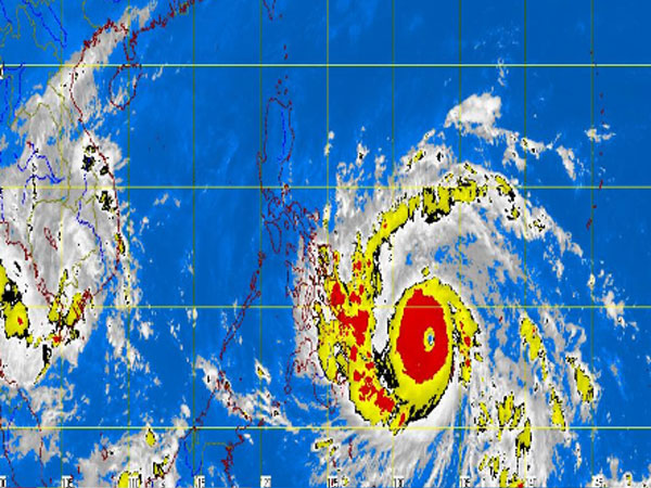
MT Satellite image November 7, 2013, Thursday, 7:30 AM. Screengrab from https://www.pagasa.dost.gov.ph/
MANILA, Philippines – “Yolanda” (international name Haiyan) is the “most powerful typhoon for 2013”, US meteorologists said Thursday, as they classified the supertyphoon as Category 5.
“The most powerful tropical cyclone of 2013 anywhere on Earth is raging toward the Philippines,” the US-based The Weather Channel reported Wednesday at 5:16 p.m. EST (6 a.m. Thursday Philippine time) .
“As of late Wednesday afternoon (US time), Super Typhoon Haiyan had top sustained winds near 175 (281 kilometers per hour) mph according to the Joint Typhoon Warning Center,” it added.
The JTWC said in an update at 5 a.m. that Yolanda was expected to remain a supertyphoon in the next 36 hours.
More areas were placed under storm signals as Yolanda (international name Haiyan) headed towards Eastern Visayas, the Philippine Atmospheric Geophysical Astronomical and Services Administration (Pagasa) said Thursday.
Yolanda is so far the strongest typhoon in the Philippines this year, said Pagasa’s Connie Dadivas . It is now packing maximum sustained winds of 215 kilometers per hour near the center and gusts of up to 250 kph.
Storm signals were raised in the following areas of Luzon, Visayas and Mindanao:
Samar
Southern Leyte
Surigao Del Norte
Siargao Island
Dinagat Island
Northern part of Surigao Del Sur
Northern part of Agusan Del Norte
Signal No. 1
Camarines Norte
Camarines Sur
Catanduanes
Albay
Sorsogon
Ticao Island
Burias Island
Masbate
Romblon
Marinduque
Southern Quezon
Aklan
Capiz
Iloilo
Antique
Guimaras
Negros Occidental and Oriental
Cebu
Camotes Island
Bohol
Siquijor
Leyte
Biliran Island
Northern Samar
Camaguin
Misamis Oriental
Rest of Agusan del Norte
Agusan del Sur
Rest of Surigao del Sur
Yolanda was last observed 822 kilometers east of Hinatuan, Surigao del Sur and continued to move west-northwest at 30 kilometers per hour. It is expected to make landfall over Eastern Visayas by Friday morning and exit the Philippine area of responsibility by early Sunday if it continues with its speed.
Heavy to intense rains were seen within its 600 kilometer-diameter. Sea travel remained risky over the eastern seaboard of Southern Luzon and Eastern Visayas.
The typhoon entered the Philippine area of responsibility Wednesday midnight.
Meanwhile, the northeast monsoon continued to affect Northern Luzon.
“Bicol Region, Visayas and Mindanao will experience cloudy skies with light to moderate rainshowers and thunderstorms. The regions of Cagayan Valley, Cordillera and Ilocos will be partly cloudy to cloudy with light rains,” Pagasa said.
Metro Manila and the rest of Luzon will have partly cloudy to cloudy skies with isolated rainshowers or thunderstorms.
Moderate to strong winds blowing from the northeast will prevail over Luzon and Visayas and coming from the northeast to north over Mindanao. The coastal waters throughout the archipelago will be moderate to rough.
Related Story:
7 areas placed under signal No. 2 as Supertyphoon ‘Yolanda’ gathers strength