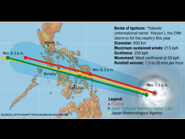
215-kph winds, heavy rains up
A storm that a weatherman describes as “a big one” is expected to make landfall in the Samar-Leyte provinces by noon on Friday and bring substantial rainfall and flooding in low-lying areas.
Local governments have announced the preemptive evacuation of people in coastal, low-lying and landslide-prone areas as they aim for zero casualties.
Rapidly intensifying over the Pacific Ocean, “Haiyan” has turned into a “supertyphoon,” steadily approaching the central part of the Philippines.
As of 5 p.m. Wednesday, the Philippine Atmospheric, Geophysical and Astronomical Services Administration (Pagasa) calculated Haiyan’s peak sustained winds at 175 kilometers per hour (kph) and gustiness at up to 210 kph.
But its weather forecasting section chief, Rene Paciente, told reporters that he expected Haiyan’s sustained winds to reach at least 215 kph “conservatively” and even up to 250 kph.
Article continues after this advertisementPotential destructive effects of a Signal No. 4 typhoon (more than 185-kph winds) include coconut plantations suffering extensive damage, many large trees uprooted, power and communication services severely disrupted, and very heavy damage to communities.
Article continues after this advertisement‘Yolanda’
The typhoon, which has a cloud cover of 600 km in diameter, would be named “Yolanda” once it arrives in the country.
Paciente said the 24th storm to hit the country this year would spawn strong winds, and heavy rains originating from the “wall” of the typhoon’s eye.
Moderate to heavy rains falling at 7.5 to 20 millimeters per hour are expected over areas directly hit by the typhoon, Paciente said.
This means that a square meter container will have collected 7.5 to 20 liters of water after an hour of rain. (A millimeter of water equals a liter of water on a square meter.)
Eye
On Wednesday afternoon, the eye of the typhoon over the Pacific Ocean was 1,221 km east of Mindanao and forecast to move west northwest at 30 kph, according to a Pagasa advisory.
Haiyan is expected to enter the Philippine area of responsibility early Thursday, and to make landfall over the Samar-Leyte provinces between 11 a.m. and 1 p.m. Friday, it added.
It will exit by early morning on Sunday, Pagasa said.
Heavily hit
Paciente said the island provinces in the central part of the country would likely be most heavily hit, including Samar and Leyte, Masbate, Romblon, northern Cebu, northern Panay, Mindoro and northern Palawan.
But he did not discount the possibility that the typhoon could track northwest-ward, in which case it would affect southern Luzon and even Metro Manila.
The Hawaii-based Joint Typhoon Warning Center (JTWC) said the typhoon had quickly strengthened over the past 24 hours from 120 kph to the current intensity of 241 kph, which qualified Haiyan as a supertyphoon by US meteorological standards.
Pagasa does not officially use supertyphoon as a classification. It calculates wind speeds based on 10-minute averages, unlike JTWC’s minute-long measurements, resulting in lower estimates.
The JTWC said that “due to very favorable environmental conditions, rapid intensification is forecast over the next 36 hours with a peak intensity expected over the Philippine Sea.”
Upon making landfall, the typhoon “will weaken as it tracks across the Philippine islands, but should emerge over the South China Sea near a 110 knot intensity (204 kph),” it added.
Moving fast
Due to its relatively fast movement, there’s a chance Haiyan might not be as destructive as some recent storms, unless it hits heavily populated areas, Paciente said.
He noted that the storms with the highest recorded wind speeds were not necessarily the most destructive or the most deadly.
Per Pagasa’s records, Typhoon “Reming” of November 2006 hit peak winds of 320 kph, followed by “Loleng” of October 1998 with 287, and “Anding” of November 1981 with 280 kph.
Even so, Paciente urged residents of Eastern Visayas to take extra precaution and to adequately prepare for the approaching typhoon.
By Thursday evening, he said he expected Signal No. 4, the highest storm alert, to be hoisted over the Visayas.
Gradually improving weather is seen over the Visayas by Saturday afternoon.
