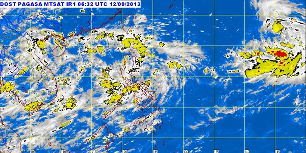
MANILA—The state weather bureau on Thursday warned residents of Eastern Visayas and the southeastern section of Luzon of the possibility of flash floods and landslides triggered by rain generated by a low pressure area spotted near Catanduanes.
As of midday Thursday, the LPA, embedded in the monsoon trough, was located 270 kilometers east of Virac, Catanduanes, the Philippine Atmospheric, Geophysical and Astronomical Services Administration (Pagasa) said.
The LPA and the monsoon trough will bring moderate to occasionally heavy rains and thunderstorms over the Bicol Region, Eastern Visayas and the provinces of Aurora and Quezon, Pagasa said.
A monsoon trough is a region of low atmospheric pressure at sea level that typically brings cloudiness and rains over the affected areas.
The weather bureau advised residents in the affected regions to take all the necessary precautionary measures.
Pagasa forecaster Aldczar Aurelio said the LPA had a chance of developing into a tropical cyclone while it remained over the water, but once it hit land, it would weaken. He said there was a strong possibility it would make landfall because of its westward movement.
According to Pagasa’s 24-hour weather outlook, Metro Manila and the rest of the country will have cloudy skies with light to moderate rain showers and thunderstorms.
Light to moderate winds blowing from the southwest to the west will prevail over Palawan, Visayas and Mindanao, while winds coming from the northeast to northwest will prevail over the rest of Luzon, it said.
Coastal waters throughout the archipelago will be slight to moderate, Pagasa said.
