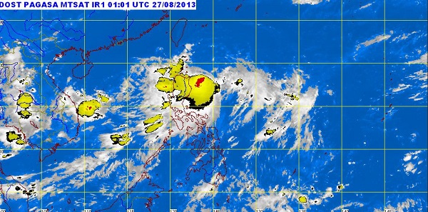
MANILA—Tropical storm “Nando” maintained strength and continued to threaten the country’s northern parts, prompting the state weather bureau to raise storm signals over more areas in extreme northern Luzon.
As of mid-Tuesday, the storm (international name: Kong-Rey) was located 210 kilometers east of Aparri, Cagayan, the Philippine Atmospheric, Geophysical and Astronomical Services Administration said.
Nando was packing winds of 75 km per hour near the center gusting up to 90 kph, forecasters said. It was moving north-northwest at 15 kph.
Public Storm Signal No. 2, indicating 61-100 kph winds, was raised in the Batanes Group of Islands, while Signal No. 1, indicating 45-60 kph winds, was up over Cagayan, the Calayan and Babuyan groups of islands, Apayao and Isabela.
Pagasa estimated that the storm would spawn heavy to intense rainfall (from 10 to 25 millimeters per hour) within its 400 kilometer diameter.
“Nando” is seen to continue bringing moderate to heavy rains to the provinces of Ilocos Norte and Ilocos Sur. It will continue to enhance the southwest monsoon, spawning light to moderate, and at times heavy, rains and thunderstorms over Metro Manila and the rest of Luzon, Pagasa said.
“Sea travel is risky over the eastern seaboard of Central and Southern Luzon,” it warned.
According to Pagasa’s 24-hour weather outlook, the Batanes group of islands will experience stormy weather with rough to very rough seas.
The provinces of Isabela, Apayao and Cagayan, including the Babuyan and Calayan groups of islands, will have rains with gusty winds and moderate to rough seas.
Metro Manila and the rest of Luzon will have cloudy skies with light to moderate rain showers and thunderstorms, while Visayas and Mindanao will be partly cloudy to cloudy with isolated rain showers or thunderstorms, Pagasa said.
Moderate to strong winds blowing from the southwest to west will prevail over Luzon, Visayas and Eastern Mindanao and the coastal waters along these areas will be moderate to rough, it said.
Elsewhere, winds will be light to moderate coming from the south to southwest with slight to moderate seas, Pagasa said.
