Typhoon ‘Labuyo’ on its way out of PH—Pagasa
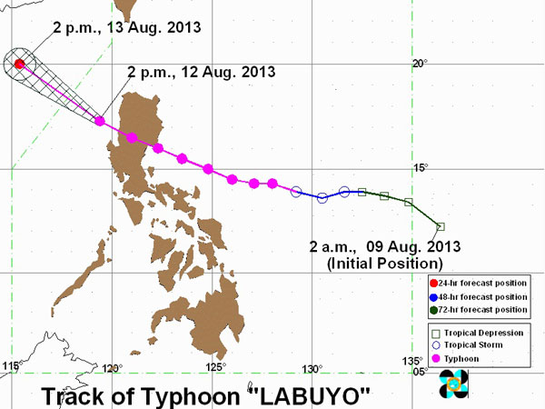
MANILA, Philippines — Typhoon “Labuyo” (international name Utor) has accelerated as it moved towards West Philippine Sea Monday afternoon, the state weather bureau said.
Fernando Cada, weather forecaster from the Philippine Atmospheric Geophysical and Astronomical Services Administration, told INQUIRER.net that Labuyo already made its way out of Philippine landmass through the west coast of La Union. It is expected to be out of the Philippine area of responsibility by Tuesday morning.
However, storm signals are still up in some areas in Luzon as Labuyo will still bring rains within its 600 kilometer diameter.
Signal No. 2 (or winds of 61-100 kilometers per hour) was raised in Nueva Vizcaya, Ifugao, Mt. Province, Ilocos Sur, Benguet, La Union and Pangasinan.
Signal No. 1, (winds of 45-60 kph), meanwhile, was hoisted over Abra, Kalinga, Apayao, Isabela, Aurora, Quirino, Nueva Ecija, Tarlac, Ilocos Norte, Pampanga, Bataan and Zambales.
Article continues after this advertisementStorm signals elsewhere were already lifted, Pagasa said.
Article continues after this advertisementLabuyo also intensified slightly, and now packed 150 kph the center and gusts of up to 185 kph.
It is forecast to move northwest at 24 kph. By Tuesday morning, it will be 480 kilometers northwest of Baguio City or outside PAR.
The typhoon was last observed 200 km west of Sinait, Ilocos Sur.
Moderate to occasionally heavy rains over the western section of Southern Luzon, Visayas and Mindanao are expected from Labuyo. It will enhance the southwest monsoon.
Labuyo, the 12th cyclone to hit the Philippines this year, is the strongest tropical cyclone for 2013, Cada said.
