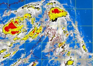
MANILA, Philippines—Tropical storm “Jolina” exited the country’s territory on Wednesday, but a new weather disturbance east of Catanduanes threatens to take its place, according to the state weather bureau.
The Philippine Atmospheric, Geophysical and Astronomical Services Administration (Pagasa) said that as of 5 p.m. Wednesday, Jolina was observed some 530 kilometers west of Subic, Zambales, packing peak winds of 65 kilometers per hour near the center and gustiness of up to 80 kph.
It was predicted to move northwest at 11 kph.
The storm is expected to continue to enhance the southwest monsoon, which could bring moderate to occasionally heavy rains and thunderstorms over the Southern Tagalog region.
Meanwhile, the new low pressure area was spotted 210 km east of Virac, Catanduanes, Pagasa said. Forecaster Jori Loiz said the weather disturbance had only a slim chance of developing into a storm, but if it did, it would be given the local name “Kiko.”
Based on Pagasa’s weather outlook for Thursday, Metro Manila and the rest of the country will have cloudy skies with light to moderate rain showers and thunderstorms.
Moderate to strong winds blowing from the southwest will prevail over Palawan and its coastal waters will be moderate to rough, it said.
Elsewhere, winds will be moderate to occasionally strong coming from the southwest to southeast with moderate to occasionally rough seas, Pagasa said.
