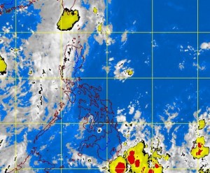
2 weather disturbances spotted outside PH area of responsibility
MANILA, Philippines — The state weather bureau is monitoring two weather disturbances outside the Philippine area of responsibility on Friday.
Elvie Enriquez, weather observer of the Philippine Atmospheric Geophysical and Astronomical Services Administration told INQUIRER.net that a low pressure area embedded along an intertropical convergence zone was being observed outside Southern Mindanao, but was still far from the country.
A tropical depression was also being monitored near the West Philippine Sea, but is unlikely to enter the Philippine area of responsibility. Should it enter the country, however, it will be called “Jolina.”
Meanwhile, a monsoon trough is affecting the western sections of Central and Northern Luzon and an ITCZ is affecting Southern Mindanao, Pagasa’s weather bulletin said.
“Batanes, Babuyan and Calayan group of islands, the provinces of Bataan, Zambales and Palawan and the regions of Ilocos, Zamboanga Peninsula, Soccsksargen and Davao will experience cloudy skies with light to moderate rainshowers and thunderstorms,” it also said.
Article continues after this advertisementMetro Manila and the rest of the country will be partly cloudy to cloudy with isolated rainshowers or thunderstorms.
Moderate to strong winds blowing from the southwest to southeast will prevail over the western section of Luzon and its coastal waters will be moderate to rough. Elsewhere, winds will be light to moderate coming from the southwest to southeast with slight to moderate seas.
