‘Isang’ signal No. 1 hoisted over parts of northern Luzon
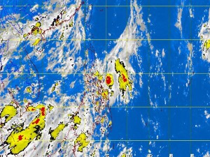
MANILA, Philippines—Signal No. 1 was raised over parts of northern Luzon Tuesday as the low pressure area spotted east of Luzon has intensified into tropical depression, which has been named “Isang.”
Ilocos Norte, Ilocos Sur, Abra, Ifugao, Cagayan (including Calayan and Babuyan group of islands,) Isabela, Quirino, Aurora, Mt. Province, Kalinga and Apayao were placed under signal No. 1 (45-60 kph winds), the Philippine Atmospheric Geophysical and Astronomical Services Administration said.
Isang will bring moderate to heavy rains within its 300-kilometer diameter. Residents in low-lying and mountainous areas under the storm signal were alerted against possible flashfloods and landslides.
The tropical depression was last observed 300 kilometers east of Infanta, Quezon, packing maximum sustained winds of 45 km per hour near the center. It was moving west northwest at 19 kph.
By Wednesday morning, Isang was forecast to be 20 km east of Tuguegarao City and by Thursday morning 230 km northwest of Itbayat, Batanes.
Article continues after this advertisementIlocos Region, Cagayan Valley, Babuyan and Calayan islands, the Cordilleras and the province of Aurora will have rains and gusty winds and moderate to rough seas, Paagasa said in a separate weather bulletin.
Article continues after this advertisementBicol Region will have cloudy skies with moderate to heavy rains and thunderstorms, which may trigger flashfloods and landslides.
Meanwhile, Metro Manila, Central Luzon, Calabarzon, Mimaropa and the Visayas will have cloudy skies with light to moderate rainshowers and thunderstorms.
Mindanao will be partly cloudy to cloudy with isolated rainshowers or thunderstorms.
Moderate to strong winds blowing from the southwest to southeast will prevail over the rest of Luzon and the coastal waters along these areas will be moderate to rough.
Elsewhere, winds will be light to moderate coming from the west to southwest with slight to moderate seas, Pagasa said.
