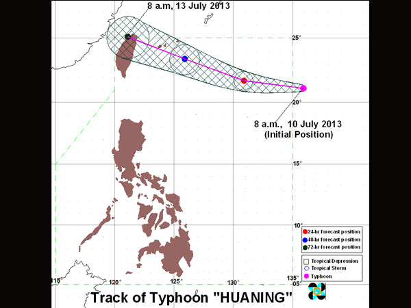
PAGASA Track as of 8 a.m., 10 July 2013
MANILA, Philippines – Typhoon Huaning (international codename: Soulik) has entered the Philippine Area of Responsibility, the state-run weather bureau said.
Huaning now packs maximum sustained winds of 175 kilometers per hour and gusts of up to 210 kph, weather forecaster Aldczar Aurelio of the Philippine Atmospheric Geophysical and Astronomical Services Administration told INQUIRER.net.
The typhoon was last observed 1,220 kilometers east of Itbayat, Batanes at 11 a.m.
It will enhance the southwest monsoon and bring rains especially over the western section.
But forecasters said they did not expect the typhoon to make landfall anywhere in the country.
Based on Pagasa’s outlook for Thursday, cloudy skies with light to moderate rain showers and thunderstorms will felt in the Mimaropa region comprising Mindoro, Marinduque, Romblon and Palawan, the Bicol Region, Western Visayas, the Zamboanga Peninsula, Soccsksargen (South Cotabato, Cotabato,Sultan Kudarat, Sarangani and General Santos City) and the provinces of Quezon and Aurora.
Metro Manila and the rest of the country will be partly cloudy to cloudy with isolated rain showers or thunderstorms, the weather bureau said.
Pagasa also issued a warning to fishing boats and other small seacraft to watch for moderate to rough seas, especially off the western seaboard of Northern Luzon (Ilocos Norte, Ilocos Sur, La Union and Pangasinan).
Huaning is expected to exit the Philippine area of responsibility Saturday morning and move toward northern Taiwan. With a report from DJ Yap, Philippine Daily Inquirer